IMAGES TAKEN NEAR TO
Allscott Way, WIGAN, WN4 8PL
Introduction
This page details the photographs taken nearby to Allscott Way, WN4 8PL by members of the Geograph project.
The Geograph project started in 2005 with the aim of publishing, organising and preserving representative images for every square kilometre of Great Britain, Ireland and the Isle of Man.

There are currently over 7.5m images from over14,400 individuals and you can help contribute to the project by visiting https://www.geograph.org.uk
Image Map
Images are licensed for reuse under creativecommons.org/licenses/by-sa/2.0
Notes
- Clicking on the map will re-center to the selected point.
- The higher the marker number, the further away the image location is from the centre of the postcode.
Image Listing (5 Images Found)
Images are licensed for reuse under creativecommons.org/licenses/by-sa/2.0
Image
Details
Distance
3
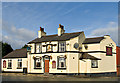
Eagle & Child
Eagle & Child - Ashton Heath
Image: © Dave Green
Taken: 2 Feb 2008
0.22 miles
5
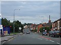
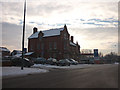
Bolton Road at its junction with Bryn Road South
Bolton Road leading to Ashton-in Makerfield town centre. The green roof of St. Oswald's church is visible in the distance.
Image: © Galatas
Taken: 5 Jul 2005
0.24 miles