IMAGES TAKEN NEAR TO
Highwoods Close, WIGAN, WN4 8EE
Introduction
This page details the photographs taken nearby to Highwoods Close, WN4 8EE by members of the Geograph project.
The Geograph project started in 2005 with the aim of publishing, organising and preserving representative images for every square kilometre of Great Britain, Ireland and the Isle of Man.

There are currently over 7.5m images from over14,400 individuals and you can help contribute to the project by visiting https://www.geograph.org.uk
Image Map
Images are licensed for reuse under creativecommons.org/licenses/by-sa/2.0
Notes
- Clicking on the map will re-center to the selected point.
- The higher the marker number, the further away the image location is from the centre of the postcode.
Image Listing (6 Images Found)
Images are licensed for reuse under creativecommons.org/licenses/by-sa/2.0
Image
Details
Distance
6
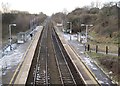
Bryn railway station, Wigan
Opened in 1869 by the Lancashire Union Railway on what is now the line from Liverpool Lime Street to Wigan.
View south west towards Garswood and Liverpool, before electrification of the line - see Image] for a similar view six years later. Minimal facilities.
Image: © Nigel Thompson
Taken: 31 Dec 2009
0.24 miles