IMAGES TAKEN NEAR TO
Garswood Road, WIGAN, WN4 0XJ
Introduction
This page details the photographs taken nearby to Garswood Road, WN4 0XJ by members of the Geograph project.
The Geograph project started in 2005 with the aim of publishing, organising and preserving representative images for every square kilometre of Great Britain, Ireland and the Isle of Man.

There are currently over 7.5m images from over14,400 individuals and you can help contribute to the project by visiting https://www.geograph.org.uk
Image Map
Images are licensed for reuse under creativecommons.org/licenses/by-sa/2.0
Notes
- Clicking on the map will re-center to the selected point.
- The higher the marker number, the further away the image location is from the centre of the postcode.
Image Listing (17 Images Found)
Images are licensed for reuse under creativecommons.org/licenses/by-sa/2.0
Image
Details
Distance
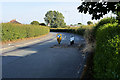
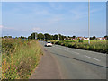
5
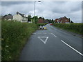
Garswood Road
Heading north near Weathercock Hill Farm.
Image: © JThomas
Taken: 5 Jun 2014
0.11 miles
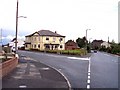
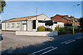
10
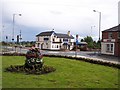
Simms Road Pub
View from crossroads of Ashton and Billinge Roads
Image: © Raymond Knapman
Taken: 7 Jul 2008
0.20 miles