IMAGES TAKEN NEAR TO
Montrey Crescent, WIGAN, WN4 0UD
Introduction
This page details the photographs taken nearby to Montrey Crescent, WN4 0UD by members of the Geograph project.
The Geograph project started in 2005 with the aim of publishing, organising and preserving representative images for every square kilometre of Great Britain, Ireland and the Isle of Man.

There are currently over 7.5m images from over14,400 individuals and you can help contribute to the project by visiting https://www.geograph.org.uk
Image Map
Images are licensed for reuse under creativecommons.org/licenses/by-sa/2.0
Notes
- Clicking on the map will re-center to the selected point.
- The higher the marker number, the further away the image location is from the centre of the postcode.
Image Listing (32 Images Found)
Images are licensed for reuse under creativecommons.org/licenses/by-sa/2.0
Image
Details
Distance
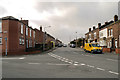
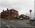
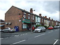
3
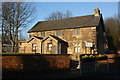
Garswood Library
Garswood Community Library on School Lane.
Image: © David Dixon
Taken: 31 Jan 2013
0.05 miles
4
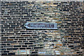
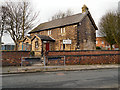
Nienhagen 670 miles
A sign on Garswood library
Image: © Ian Greig
Taken: 11 Dec 2009
0.06 miles
9
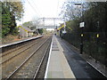
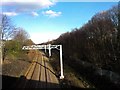
Garswood railway station, Merseyside
Opened in 1869 by the Lancashire Union Railway on what is now the line from Liverpool Lime Street to Wigan.
View north east towards Bryn and Wigan shortly after electrification. See Image] for a similar view six years earlier.
Image: © Nigel Thompson
Taken: 10 Nov 2015
0.09 miles