IMAGES TAKEN NEAR TO
Ledmore Grove, WIGAN, WN4 0RT
Introduction
This page details the photographs taken nearby to Ledmore Grove, WN4 0RT by members of the Geograph project.
The Geograph project started in 2005 with the aim of publishing, organising and preserving representative images for every square kilometre of Great Britain, Ireland and the Isle of Man.

There are currently over 7.5m images from over14,400 individuals and you can help contribute to the project by visiting https://www.geograph.org.uk
Image Map
Images are licensed for reuse under creativecommons.org/licenses/by-sa/2.0
Notes
- Clicking on the map will re-center to the selected point.
- The higher the marker number, the further away the image location is from the centre of the postcode.
Image Listing (34 Images Found)
Images are licensed for reuse under creativecommons.org/licenses/by-sa/2.0
Image
Details
Distance
1
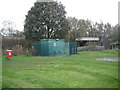
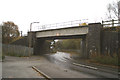
Waste water pumping station
Next to railway bridge over Strange Road
Image: © Eileen Littler
Taken: 21 Oct 2011
0.04 miles
2
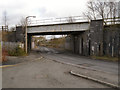
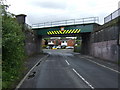
Garswood, Strange Road Bridge
Bridge taking the railway over Strange Road at Garswood.
Image: © David Dixon
Taken: 31 Jan 2013
0.05 miles

6
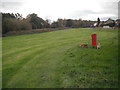
Popular dog walking area in Garswood
Three poo bins provided, but some people don't use them!!
Image: © Eileen Littler
Taken: 21 Oct 2011
0.11 miles
7
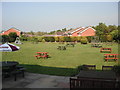
Railway Hotel Beer Garden
The extensive grassed beer garden-cum-playing area.
Image: © Eileen Littler
Taken: 21 May 2012
0.12 miles
8

The Railway, Station Road
Public house opposite Garswood Station.
Image: © David Dixon
Taken: 31 Jan 2013
0.13 miles