IMAGES TAKEN NEAR TO
Hale Grove, WIGAN, WN4 0LU
Introduction
This page details the photographs taken nearby to Hale Grove, WN4 0LU by members of the Geograph project.
The Geograph project started in 2005 with the aim of publishing, organising and preserving representative images for every square kilometre of Great Britain, Ireland and the Isle of Man.

There are currently over 7.5m images from over14,400 individuals and you can help contribute to the project by visiting https://www.geograph.org.uk
Image Map
Images are licensed for reuse under creativecommons.org/licenses/by-sa/2.0
Notes
- Clicking on the map will re-center to the selected point.
- The higher the marker number, the further away the image location is from the centre of the postcode.
Image Listing (10 Images Found)
Images are licensed for reuse under creativecommons.org/licenses/by-sa/2.0
Image
Details
Distance
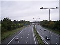
1
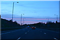
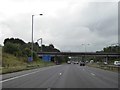
Metropolitan Borough of Wigan : The M6 Motorway
Heading north through the Metropolitan Borough of Wigan near Bryn.
Image: © Lewis Clarke
Taken: 21 Apr 2016
0.12 miles
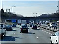
5
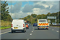
Ashton-in-Makerfield : M6 Motorway
The M6 Motorway between Junction 24 and Junction 25.
Image: © Lewis Clarke
Taken: 23 Sep 2019
0.15 miles
7

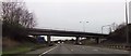
Metropolitan Borough of Wigan : The M6 Motorway
Heading north along the M6 Motorway as it heads under the railway bridge.
Image: © Lewis Clarke
Taken: 21 Apr 2016
0.18 miles
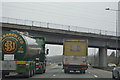
8
M6 viewed north from Spindle Hillock road bridge
Image: © Raymond Knapman
Taken: 10 Sep 2010
0.21 miles