IMAGES TAKEN NEAR TO
Chimes Road, WIGAN, WN4 0LA
Introduction
This page details the photographs taken nearby to Chimes Road, WN4 0LA by members of the Geograph project.
The Geograph project started in 2005 with the aim of publishing, organising and preserving representative images for every square kilometre of Great Britain, Ireland and the Isle of Man.

There are currently over 7.5m images from over14,400 individuals and you can help contribute to the project by visiting https://www.geograph.org.uk
Image Map
Images are licensed for reuse under creativecommons.org/licenses/by-sa/2.0
Notes
- Clicking on the map will re-center to the selected point.
- The higher the marker number, the further away the image location is from the centre of the postcode.
Image Listing (16 Images Found)
Images are licensed for reuse under creativecommons.org/licenses/by-sa/2.0
Image
Details
Distance
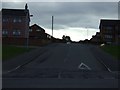
1
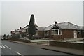
Suburbia in Wigan
South of Souchers Lane.
Image: © David Long
Taken: 29 Dec 2005
0.12 miles
5
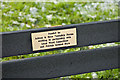
Bench plaque
Bench plaque - see memorial bench at Bryn
Image: © Dave Green
Taken: 2 Feb 2008
0.19 miles
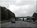
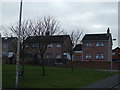
8
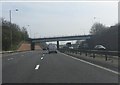
M6, Bryn
Bridge carrying Downall Green Road (B5207) over the M6.
Image: © David Dixon
Taken: 17 Sep 2010
0.21 miles