IMAGES TAKEN NEAR TO
Drummers Lane, WIGAN, WN4 0JA
Introduction
This page details the photographs taken nearby to Drummers Lane, WN4 0JA by members of the Geograph project.
The Geograph project started in 2005 with the aim of publishing, organising and preserving representative images for every square kilometre of Great Britain, Ireland and the Isle of Man.

There are currently over 7.5m images from over14,400 individuals and you can help contribute to the project by visiting https://www.geograph.org.uk
Image Map
Images are licensed for reuse under creativecommons.org/licenses/by-sa/2.0
Notes
- Clicking on the map will re-center to the selected point.
- The higher the marker number, the further away the image location is from the centre of the postcode.
Image Listing (8 Images Found)
Images are licensed for reuse under creativecommons.org/licenses/by-sa/2.0
Image
Details
Distance
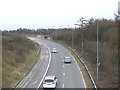
1
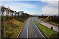
The M6 slip road
Heading towards Wigan (south) or Ashton in Makerfield (north)
Image: © Ian Greig
Taken: 13 Nov 2009
0.05 miles
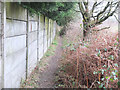
2
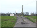
Track from Drummer's Lane to Doe Ridings
Image: © Gary Rogers
Taken: 12 Mar 2017
0.06 miles
4
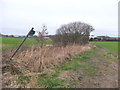
Footpath from Drummer's Lane to the A49 Wigan Road at Bryn
Image: © Gary Rogers
Taken: 12 Mar 2017
0.20 miles
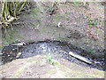
5
Footpath from Drummer's Lane to the A49 Wigan Road at Bryn
Image: © Gary Rogers
Taken: 12 Mar 2017
0.22 miles
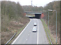
6
M6 Southbound access road from A49 at Junction 25
Image: © Gary Rogers
Taken: 12 Mar 2017
0.22 miles
8
M6 Junction 25 Northbound Exit road to A49
Image: © Gary Rogers
Taken: 12 Mar 2017
0.25 miles