IMAGES TAKEN NEAR TO
Parkside Avenue, WIGAN, WN4 0DS
Introduction
This page details the photographs taken nearby to Parkside Avenue, WN4 0DS by members of the Geograph project.
The Geograph project started in 2005 with the aim of publishing, organising and preserving representative images for every square kilometre of Great Britain, Ireland and the Isle of Man.

There are currently over 7.5m images from over14,400 individuals and you can help contribute to the project by visiting https://www.geograph.org.uk
Image Map
Images are licensed for reuse under creativecommons.org/licenses/by-sa/2.0
Notes
- Clicking on the map will re-center to the selected point.
- The higher the marker number, the further away the image location is from the centre of the postcode.
Image Listing (19 Images Found)
Images are licensed for reuse under creativecommons.org/licenses/by-sa/2.0
Image
Details
Distance
7
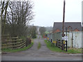
Track at Land Gate, South of Haslemere Industrial Estate
Image: © Gary Rogers
Taken: 12 Mar 2017
0.09 miles
8
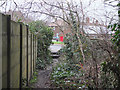
End of path between Drummer's Lane and Wigan Road at Bryn
Image: © Gary Rogers
Taken: 12 Mar 2017
0.10 miles
10
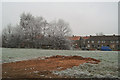
Scratch the surface
The new roofs on the houses behind show which are still in public ownership - those with their original tiles are privately-owned.
Image: © David Long
Taken: 29 Dec 2005
0.13 miles