IMAGES TAKEN NEAR TO
Cranberry Court, WIGAN, WN4 0BN
Introduction
This page details the photographs taken nearby to Cranberry Court, WN4 0BN by members of the Geograph project.
The Geograph project started in 2005 with the aim of publishing, organising and preserving representative images for every square kilometre of Great Britain, Ireland and the Isle of Man.

There are currently over 7.5m images from over14,400 individuals and you can help contribute to the project by visiting https://www.geograph.org.uk
Image Map
Images are licensed for reuse under creativecommons.org/licenses/by-sa/2.0
Notes
- Clicking on the map will re-center to the selected point.
- The higher the marker number, the further away the image location is from the centre of the postcode.
Image Listing (13 Images Found)
Images are licensed for reuse under creativecommons.org/licenses/by-sa/2.0
Image
Details
Distance
1

Hazlemere Industrial Estate, Land Gate. M6 Junction 25
Image: © Gary Rogers
Taken: 12 Mar 2017
0.02 miles
2
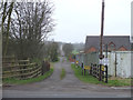
Track at Land Gate, South of Haslemere Industrial Estate
Image: © Gary Rogers
Taken: 12 Mar 2017
0.06 miles
10
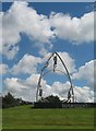
Roundabout at junction of M6 with Warrington Rd
Sculpture on the roundabout at the junction of the M6 slip road with Warrington Rd.
Image: © Sue Adair
Taken: 22 Jul 2007
0.17 miles