IMAGES TAKEN NEAR TO
Fardon Close, WIGAN, WN3 6SN
Introduction
This page details the photographs taken nearby to Fardon Close, WN3 6SN by members of the Geograph project.
The Geograph project started in 2005 with the aim of publishing, organising and preserving representative images for every square kilometre of Great Britain, Ireland and the Isle of Man.

There are currently over 7.5m images from over14,400 individuals and you can help contribute to the project by visiting https://www.geograph.org.uk
Image Map
Images are licensed for reuse under creativecommons.org/licenses/by-sa/2.0
Notes
- Clicking on the map will re-center to the selected point.
- The higher the marker number, the further away the image location is from the centre of the postcode.
Image Listing (18 Images Found)
Images are licensed for reuse under creativecommons.org/licenses/by-sa/2.0
Image
Details
Distance
1
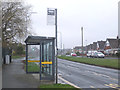
Bus Stop on Highfield Grange Avenue, Marus Bridge
Image: © Gary Rogers
Taken: 12 Mar 2017
0.07 miles
2
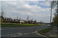
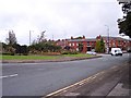
Daffs in bloom on Highfield Grange Avenue, Marus Bridge
Image: © David Long
Taken: 2 Apr 2009
0.10 miles
3
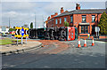
Floral roundabout on Warrington Road at Goose Green
Image: © Raymond Knapman
Taken: 9 Sep 2010
0.12 miles
4
Overturned Lorry
At Marus Bridge Roundabout
Image: © Dave Green
Taken: 30 Apr 2008
0.13 miles
5
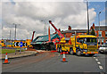
Overturned Lorry
At Marus Bridge Roundabout
Image: © Dave Green
Taken: 30 Apr 2008
0.14 miles
7
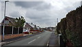
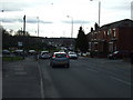
Crestwood Avenue, Bryn
A quiet residential street in the suburbs of Wigan.
Image: © Peter Mackenzie
Taken: 1 May 2019
0.14 miles