IMAGES TAKEN NEAR TO
Weybourne Drive, WIGAN, WN3 6RL
Introduction
This page details the photographs taken nearby to Weybourne Drive, WN3 6RL by members of the Geograph project.
The Geograph project started in 2005 with the aim of publishing, organising and preserving representative images for every square kilometre of Great Britain, Ireland and the Isle of Man.

There are currently over 7.5m images from over14,400 individuals and you can help contribute to the project by visiting https://www.geograph.org.uk
Image Map
Images are licensed for reuse under creativecommons.org/licenses/by-sa/2.0
Notes
- Clicking on the map will re-center to the selected point.
- The higher the marker number, the further away the image location is from the centre of the postcode.
Image Listing (8 Images Found)
Images are licensed for reuse under creativecommons.org/licenses/by-sa/2.0
Image
Details
Distance

2

The Freemasons
Pub, Clap Gate, Goose Green.
Image: © Richard Webb
Taken: 17 Apr 2016
0.11 miles
3
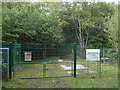
Smithy Brook Park minewater treatment scheme, Goose Green
Operated by the Coal Authority
Image: © Gary Rogers
Taken: 12 Sep 2015
0.14 miles
4
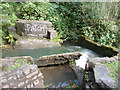
Weir on Smithy Brook in Blundell's Wood, Winstanley
Image: © Gary Rogers
Taken: 12 Sep 2015
0.18 miles

6
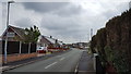
Crestwood Avenue, Bryn
A quiet residential street in the suburbs of Wigan.
Image: © Peter Mackenzie
Taken: 1 May 2019
0.23 miles
7

St Paul's Church, Goose Green, Wigan
Architect W. Chasen Ralph, 1915
Image: © S Parish
Taken: Unknown
0.25 miles
