IMAGES TAKEN NEAR TO
Pepperwood Drive, WIGAN, WN3 6NB
Introduction
This page details the photographs taken nearby to Pepperwood Drive, WN3 6NB by members of the Geograph project.
The Geograph project started in 2005 with the aim of publishing, organising and preserving representative images for every square kilometre of Great Britain, Ireland and the Isle of Man.

There are currently over 7.5m images from over14,400 individuals and you can help contribute to the project by visiting https://www.geograph.org.uk
Image Map
Images are licensed for reuse under creativecommons.org/licenses/by-sa/2.0
Notes
- Clicking on the map will re-center to the selected point.
- The higher the marker number, the further away the image location is from the centre of the postcode.
Image Listing (13 Images Found)
Images are licensed for reuse under creativecommons.org/licenses/by-sa/2.0
Image
Details
Distance
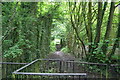
2

Footbridge over stream on path in Tan Pit Wood
Image: © Gary Rogers
Taken: 16 Feb 2015
0.18 miles

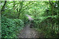
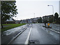
6
Track north of Tan Pit Wood, Winstanley
Image: © Gary Rogers
Taken: 16 Feb 2015
0.20 miles
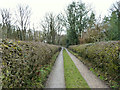
7
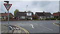
Clapgate Lane, Bryn
The junction of Clapgate Lane in Bryn.
Image: © Peter Mackenzie
Taken: 1 May 2019
0.21 miles
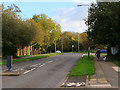
9
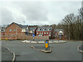
Roundabout at end of Holmes House Avenue, Winstanley
Image: © Gary Rogers
Taken: 16 Feb 2015
0.22 miles
10
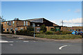
St Aidan's RC Church and Parish Centre, Winstanley
Image: © David Dixon
Taken: 27 Oct 2019
0.22 miles