IMAGES TAKEN NEAR TO
Wirral Drive, WIGAN, WN3 6LD
Introduction
This page details the photographs taken nearby to Wirral Drive, WN3 6LD by members of the Geograph project.
The Geograph project started in 2005 with the aim of publishing, organising and preserving representative images for every square kilometre of Great Britain, Ireland and the Isle of Man.

There are currently over 7.5m images from over14,400 individuals and you can help contribute to the project by visiting https://www.geograph.org.uk
Image Map
Images are licensed for reuse under creativecommons.org/licenses/by-sa/2.0
Notes
- Clicking on the map will re-center to the selected point.
- The higher the marker number, the further away the image location is from the centre of the postcode.
Image Listing (18 Images Found)
Images are licensed for reuse under creativecommons.org/licenses/by-sa/2.0
Image
Details
Distance
1
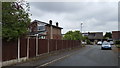
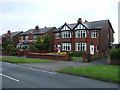
Cambrian Crescent
Houses in this quiet residential suburb.
Image: © Peter Mackenzie
Taken: 1 May 2019
0.08 miles
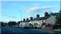
2
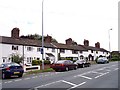
Cottages on Pemberton Road Winstanley
Image: © Raymond Knapman
Taken: 27 Jul 2010
0.09 miles
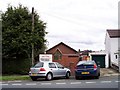
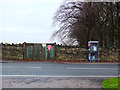
4
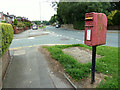
GR Postbox at junction of Pemberton Road and Tan House Lane
Image: © Gary Rogers
Taken: 13 Aug 2015
0.10 miles
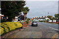
6
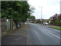
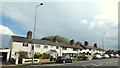
Pemberton Road (A571)
Heading north east towards Wigan.
Image: © JThomas
Taken: 5 Jun 2014
0.11 miles
7
The tiny church on Pemberton Road Winstanley
Image: © Raymond Knapman
Taken: 27 Jul 2010
0.11 miles
10
Entrance to the Winstanley Hall estate on Pemberton Road
Image: © Gary Rogers
Taken: 10 Dec 2016
0.13 miles