IMAGES TAKEN NEAR TO
Stephens Way, Warrington Road Industrial Estate, WIGAN, WN3 6GW
Introduction
This page details the photographs taken nearby to Stephens Way, Warrington Road Industrial Estate, WN3 6GW by members of the Geograph project.
The Geograph project started in 2005 with the aim of publishing, organising and preserving representative images for every square kilometre of Great Britain, Ireland and the Isle of Man.

There are currently over 7.5m images from over14,400 individuals and you can help contribute to the project by visiting https://www.geograph.org.uk
Image Map
Images are licensed for reuse under creativecommons.org/licenses/by-sa/2.0
Notes
- Clicking on the map will re-center to the selected point.
- The higher the marker number, the further away the image location is from the centre of the postcode.
Image Listing (12 Images Found)
Images are licensed for reuse under creativecommons.org/licenses/by-sa/2.0
Image
Details
Distance
1
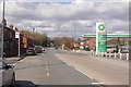
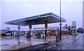
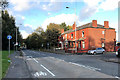
Warrington Road, Wigan
The A49 on the south side of Wigan. The filling station was charging £1.08 / l for both petrol and diesel. This is a BP station and they are usually more expensive.
Image: © Richard Webb
Taken: 17 Apr 2016
0.11 miles
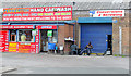
2
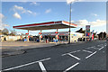
Esso Filling Station on Warrington Road, Wigan
Image: © David Dixon
Taken: 27 Oct 2019
0.11 miles
7
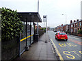
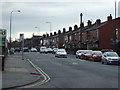
Bus stop on A571 Billinge Road, Newtown
Image: © Gary Rogers
Taken: 10 Dec 2016
0.20 miles
10
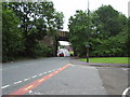
Skew Bridge
This bridge carries the Wigan to Kirkby (originally Liverpool exchange) railway over the A49. Known locally as "Skew Bridge".
Image: © David Ashcroft
Taken: 21 Jun 2006
0.22 miles