IMAGES TAKEN NEAR TO
Watkin Close, WIGAN, WN3 6GP
Introduction
This page details the photographs taken nearby to Watkin Close, WN3 6GP by members of the Geograph project.
The Geograph project started in 2005 with the aim of publishing, organising and preserving representative images for every square kilometre of Great Britain, Ireland and the Isle of Man.

There are currently over 7.5m images from over14,400 individuals and you can help contribute to the project by visiting https://www.geograph.org.uk
Image Map
Images are licensed for reuse under creativecommons.org/licenses/by-sa/2.0
Notes
- Clicking on the map will re-center to the selected point.
- The higher the marker number, the further away the image location is from the centre of the postcode.
Image Listing (18 Images Found)
Images are licensed for reuse under creativecommons.org/licenses/by-sa/2.0
Image
Details
Distance
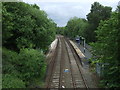
1
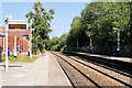
Pemberton Railway Station (view west)
Looking west, towards Wigan.
The station was opened on 20 November 1848 by the Liverpool and Bury Railway it now serves the Kirkby branch line from Wigan Wallgate. There are basic passenger shelters on both platforms.
Image: © David Dixon
Taken: 23 Jul 2019
0.15 miles
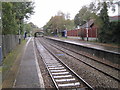
3
Pemberton Railway Station (view east)
Looking east, towards Liverpool.
The station was opened on 20 November 1848 by the Liverpool and Bury Railway it now serves the Kirkby branch line from Wigan Wallgate. There are basic passenger shelters on both platforms.
Image: © David Dixon
Taken: 23 Jul 2019
0.16 miles
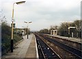
4
Pemberton railway station, Greater Manchester
Opened in 1848 by the Lancashire and Yorkshire Railway on what became the line from Liverpool Exchange to Manchester Victoria via Wigan. When this image was taken, passengers from Liverpool to Wigan by this line needed to change trains at Kirkby.
View west towards Orrell and Liverpool.
Image: © Nigel Thompson
Taken: 13 Oct 2012
0.16 miles
6
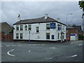
The Railway pub
Near Pemberton Railway Station.
Image: © JThomas
Taken: 5 Jun 2014
0.18 miles
7
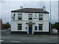
The Railway pub
Near Pemberton Railway Station.
Image: © JThomas
Taken: 5 Jun 2014
0.18 miles
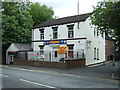
8
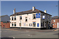
The Railway
Public house on the corner of Enfield Street and Billinge Road, opposite Pemberton railway station.
Image: © David Dixon
Taken: 23 Jul 2019
0.18 miles
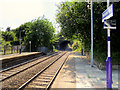
10
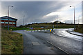
A roundabout to no-where
This roundabout, served by an impressive traffic light junction on the A49, leads to an, as yet, unbuilt estate.
Image: © Ian Greig
Taken: 6 Dec 2009
0.20 miles