IMAGES TAKEN NEAR TO
Holmes House Avenue, WIGAN, WN3 6EA
Introduction
This page details the photographs taken nearby to Holmes House Avenue, WN3 6EA by members of the Geograph project.
The Geograph project started in 2005 with the aim of publishing, organising and preserving representative images for every square kilometre of Great Britain, Ireland and the Isle of Man.

There are currently over 7.5m images from over14,400 individuals and you can help contribute to the project by visiting https://www.geograph.org.uk
Image Map
Images are licensed for reuse under creativecommons.org/licenses/by-sa/2.0
Notes
- Clicking on the map will re-center to the selected point.
- The higher the marker number, the further away the image location is from the centre of the postcode.
Image Listing (25 Images Found)
Images are licensed for reuse under creativecommons.org/licenses/by-sa/2.0
Image
Details
Distance
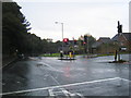
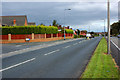
1
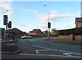
Traffic Light controlled junction in Winstanley
Image: © Anthony Parkes
Taken: 3 Jul 2013
0.03 miles
3
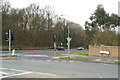
Junction of Holmes House Avenue with the A571
Image: © David Long
Taken: 2 Apr 2009
0.05 miles
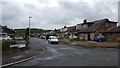
4
Pemberton Road/Holmes House Avenue junction
Image: © Colin Pyle
Taken: 26 Sep 2012
0.05 miles
5
Malvern Close
Residential properties in this quiet housing estate.
Image: © Peter Mackenzie
Taken: 1 May 2019
0.06 miles
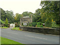
6
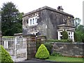
Wigan Lodge on Pemberton Road Winstanley
Image: © Raymond Knapman
Taken: 27 Jul 2010
0.06 miles
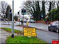
7
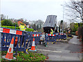
Roadworks on the A571 Pemberton Road
Electricity infrastructure work
Image: © Gary Rogers
Taken: 10 Dec 2016
0.09 miles
9
Wigan Lodge, Pemberton Road, Winstanley
Image: © Gary Rogers
Taken: 12 Sep 2015
0.12 miles