IMAGES TAKEN NEAR TO
Alderney Drive, WIGAN, WN3 5QA
Introduction
This page details the photographs taken nearby to Alderney Drive, WN3 5QA by members of the Geograph project.
The Geograph project started in 2005 with the aim of publishing, organising and preserving representative images for every square kilometre of Great Britain, Ireland and the Isle of Man.

There are currently over 7.5m images from over14,400 individuals and you can help contribute to the project by visiting https://www.geograph.org.uk
Image Map
Images are licensed for reuse under creativecommons.org/licenses/by-sa/2.0
Notes
- Clicking on the map will re-center to the selected point.
- The higher the marker number, the further away the image location is from the centre of the postcode.
Image Listing (21 Images Found)
Images are licensed for reuse under creativecommons.org/licenses/by-sa/2.0
Image
Details
Distance
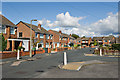
1
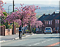
Cyclist and Cherry Trees
Poolstock Lane, Marus Bridge
Image: © Dave Green
Taken: 29 Apr 2008
0.09 miles
3
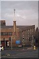
St Jude's Church, corner of Poolstock Lane and St Paul's Avenue, Goose Green
Image: © David Long
Taken: 4 Jan 2010
0.13 miles
4
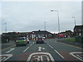
St Pauls Avenue at Poolstock Lane junction
Image: © Colin Pyle
Taken: 11 Nov 2017
0.13 miles
5
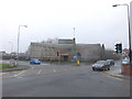
St Jude's Church
The Catholic Church of St Jude at the corner of St Paul's Avenue and Poolstock Lane, Goose Green.
Image: © David Dixon
Taken: 6 May 2013
0.15 miles
6
St Jude's Church, corner of Poolstock Lane and St Paul's Avenue, Goose Green
Image: © Gary Rogers
Taken: 12 Mar 2017
0.15 miles
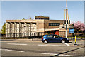
8
The Hawk pub, Hawkley, Wigan
At the junction of Carr Lane and Stewart Road
Image: © Gary Rogers
Taken: 12 Mar 2017
0.16 miles
9
The Catholic Church of St Jude, Goose Green
Image: © David Dixon
Taken: 6 May 2013
0.17 miles