IMAGES TAKEN NEAR TO
WN3 5EF
Introduction
This page details the photographs taken nearby to WN3 5EF by members of the Geograph project.
The Geograph project started in 2005 with the aim of publishing, organising and preserving representative images for every square kilometre of Great Britain, Ireland and the Isle of Man.

There are currently over 7.5m images from over14,400 individuals and you can help contribute to the project by visiting https://www.geograph.org.uk
Image Map
Images are licensed for reuse under creativecommons.org/licenses/by-sa/2.0
Notes
- Clicking on the map will re-center to the selected point.
- The higher the marker number, the further away the image location is from the centre of the postcode.
Image Listing (5 Images Found)
Images are licensed for reuse under creativecommons.org/licenses/by-sa/2.0
Image
Details
Distance
1
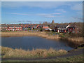
New residential development in Poolstock
View looking North across the pond in the South of the square. St James' church close to the roundabout in the centre east of the square can also be seen.
Image: © Gary Rogers
Taken: Unknown
0.15 miles
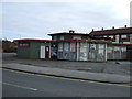
3

Parson's Meadow
Looking towards St James' Church Poolstock.
Image: © Dave Green
Taken: 11 Oct 2005
0.19 miles
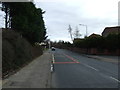
5
B5238 Poolstock Lane at Worsley Mesnes Drive
Image: © Colin Pyle
Taken: 11 Nov 2017
0.24 miles