IMAGES TAKEN NEAR TO
Taylors Lane, WIGAN, WN3 4TZ
Introduction
This page details the photographs taken nearby to Taylors Lane, WN3 4TZ by members of the Geograph project.
The Geograph project started in 2005 with the aim of publishing, organising and preserving representative images for every square kilometre of Great Britain, Ireland and the Isle of Man.

There are currently over 7.5m images from over14,400 individuals and you can help contribute to the project by visiting https://www.geograph.org.uk
Image Map
Images are licensed for reuse under creativecommons.org/licenses/by-sa/2.0
Notes
- Clicking on the map will re-center to the selected point.
- The higher the marker number, the further away the image location is from the centre of the postcode.
Image Listing (71 Images Found)
Images are licensed for reuse under creativecommons.org/licenses/by-sa/2.0
Image
Details
Distance
1

Taylors Lane & Arley Street, Spring View
Where there is open space, and the newer homes on the right, there once stood terraced housing. Subsidence from a major fault disturbed by coal mining caused their demolition.
Image: © David Long
Taken: 14 Dec 2006
0.01 miles
3
Arley Street, Spring View
The longest length of cobbled street in the Parish. The new houses here replace terraces knocked down after suffering from subsidence caused by a fault disturbed by mining the Arley seam, among others, beneath the ground here.
Image: © David Long
Taken: 14 Jul 2007
0.03 miles
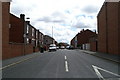
4
Looking North down Elizabethan Drive, Spring View
Image: © David Long
Taken: 23 Mar 2007
0.04 miles
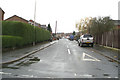
5
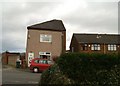
Do not adjust your set
The house really does lean over like that. Most of the older properties on Taylors Lane, including a Welsh Chapel, were pulled decades ago, largely through subsidence as a major fault beneath them was disturbed by coal workings. Only this house still stands, at the end of Elizabethan Drive.
Image: © David Long
Taken: 23 Mar 2007
0.05 miles
6
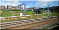
Taylors Lane railway bridge
A short spur from Springs Branch Depot passes under the visible span of the bridge. Viewed from a train heading to Manchester Airport, which is about to pass under another span of the bridge.
Image: © Thomas Nugent
Taken: 6 Jul 2020
0.06 miles
7
Eastern end of Elizabethan Drive, Spring View
Image: © David Long
Taken: 14 Dec 2006
0.06 miles
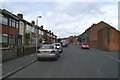
8
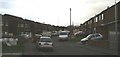
Looking South down Hey Street, Spring View
Image: © David Long
Taken: 14 Jul 2007
0.06 miles
9
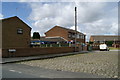
Looking North up Hey Street, Spring View
The wall and building on the right are the western boundary of the former Ince Police Station, presently empty and disused.
Image: © David Long
Taken: 14 Jul 2007
0.07 miles
10
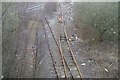
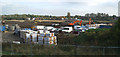
Manchester Junction, from Taylors Lane Bridge, Spring View
The left-hand track is overgrown with small trees. A section of the right-hand track is still used occasionally in connection with shunting operations by the Springs Branch sheds.
Image: © David Long
Taken: 23 Mar 2007
0.07 miles