IMAGES TAKEN NEAR TO
Warrington Road, WIGAN, WN3 4TF
Introduction
This page details the photographs taken nearby to Warrington Road, WN3 4TF by members of the Geograph project.
The Geograph project started in 2005 with the aim of publishing, organising and preserving representative images for every square kilometre of Great Britain, Ireland and the Isle of Man.

There are currently over 7.5m images from over14,400 individuals and you can help contribute to the project by visiting https://www.geograph.org.uk
Image Map
Images are licensed for reuse under creativecommons.org/licenses/by-sa/2.0
Notes
- Clicking on the map will re-center to the selected point.
- The higher the marker number, the further away the image location is from the centre of the postcode.
Image Listing (68 Images Found)
Images are licensed for reuse under creativecommons.org/licenses/by-sa/2.0
Image
Details
Distance
1
Field Street, Spring View
The Walmesley Arms is on the left.
Image: © David Long
Taken: 14 Dec 2006
0.01 miles
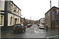
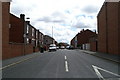
2
Warrington Road near Spring View
The A573 between Platt Bridge and Ince.
Image: © David Dixon
Taken: 21 Jul 2019
0.02 miles
4
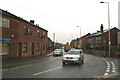
Warrington Road, Spring View - the A573
Looking South, at its junction with Taylors Lane.
Image: © David Long
Taken: 14 Dec 2006
0.03 miles
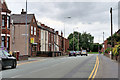
5
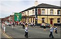
The Walmesley Arms, Warrington Road, Spring View on St. Mary's Walking Day
Image: © David Long
Taken: 13 Jun 2004
0.03 miles
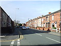
6
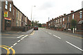
Warrington Road, Spring View, junction with St. Clements Street
Image: © David Long
Taken: 25 Oct 2006
0.04 miles
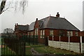
8
South-West view of St. Mary's CofE School
This School appears to have been built the wrong way round - this view, and the one from the South-East, show its main architectural features - facing open space, and out of sight from the road. The side facing the road, seen in the first view to be posted here, is plain in comparison.
Image: © David Long
Taken: 23 Feb 2007
0.06 miles
9
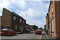
Looking South down Hey Street, Spring View
Image: © David Long
Taken: 14 Jul 2007
0.06 miles
10
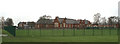
South-East corner, St. Mary's CofE School
The second of three views of this School, which was built as a Council School in 1906, later became a Secondary School, and then in 1974 became the replacement for the Church Primary School, which was in buildings erected in 1861 and 1875.
Image: © David Long
Taken: 14 Dec 2006
0.06 miles