IMAGES TAKEN NEAR TO
Woodlands Avenue, WIGAN, WN3 4QZ
Introduction
This page details the photographs taken nearby to Woodlands Avenue, WN3 4QZ by members of the Geograph project.
The Geograph project started in 2005 with the aim of publishing, organising and preserving representative images for every square kilometre of Great Britain, Ireland and the Isle of Man.

There are currently over 7.5m images from over14,400 individuals and you can help contribute to the project by visiting https://www.geograph.org.uk
Image Map
Images are licensed for reuse under creativecommons.org/licenses/by-sa/2.0
Notes
- Clicking on the map will re-center to the selected point.
- The higher the marker number, the further away the image location is from the centre of the postcode.
Image Listing (59 Images Found)
Images are licensed for reuse under creativecommons.org/licenses/by-sa/2.0
Image
Details
Distance
1
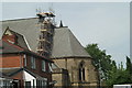
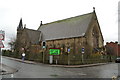
Under Repair
Christ Church, Ince, undergoing repairs. The steel rod which secures the Celtic Cross on the East end of the church has corroded and must be replaced. Further problems have been revealed by a close inspection of the stonework around. It's going to be an expensive job....
Image: © David Long
Taken: 12 May 2008
0.02 miles
2
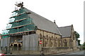
Under repair
Christ Church, Higher Ince, undergoing repairs following the statutory Quinquennial Inspection which all Anglican churches must have, and act upon, to keep the building in good repair.
Image: © David Long
Taken: 3 Jun 2009
0.03 miles
3
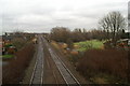
Track of canal branch
The green area is where a branch of the Leeds & Liverpool Canal reached out to serve pits and factories south of the Wigan Flight. The railway was bridged over it. Viaduct Terrace once lay along the line of trees.
Image: © David Long
Taken: 21 Dec 2005
0.04 miles
4
Repairs to Christ Church, Ince
Viewed from across the bridge taking Ince Green Lane over the Southport-Wigan-Manchester railway line.
Image: © David Long
Taken: 12 May 2008
0.05 miles
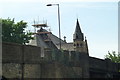
5

Ince Green Lane bridges the Wigan Manchester railway
The road is reduced to single carriageway on the bridge.The spire of Christ Church is seen on the left over the bridge.Ince railway station is on the right
Image: © Raymond Knapman
Taken: 3 Sep 2010
0.07 miles
6
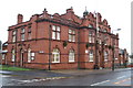
Ince Public Hall
Formerly the Offices for Ince Urban District Council. Since the 1974 reorganisation Ince has been part of the Wigan Metropolitan District in Greater Manchester.
Image: © David Long
Taken: 21 Dec 2005
0.08 miles
7
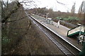
Higher Ince Station on the Wigan-Bolton-Manchester line
Looking towards Wigan
Image: © David Long
Taken: 21 Dec 2005
0.08 miles
8
WW2 Memorial, Christ Church, Higher Ince
The church's peal of bells was installed as a WW2 Memorial. Unfortunately the plaque, though recently renewed, still lacks about two dozen known local casulaties.
Image: © David Long
Taken: 21 Dec 2005
0.08 miles
10
Former Surgery, Manley Street
Soon after this shot was taken, the Surgery was moved to temporary accommodation off Warrington Road, a view of which follows.
Image: © David Long
Taken: Unknown
0.08 miles