IMAGES TAKEN NEAR TO
Oxburgh Road, WIGAN, WN3 4PN
Introduction
This page details the photographs taken nearby to Oxburgh Road, WN3 4PN by members of the Geograph project.
The Geograph project started in 2005 with the aim of publishing, organising and preserving representative images for every square kilometre of Great Britain, Ireland and the Isle of Man.

There are currently over 7.5m images from over14,400 individuals and you can help contribute to the project by visiting https://www.geograph.org.uk
Image Map
Images are licensed for reuse under creativecommons.org/licenses/by-sa/2.0
Notes
- Clicking on the map will re-center to the selected point.
- The higher the marker number, the further away the image location is from the centre of the postcode.
Image Listing (22 Images Found)
Images are licensed for reuse under creativecommons.org/licenses/by-sa/2.0
Image
Details
Distance
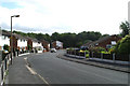
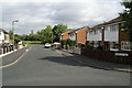
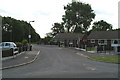
2
Chatsworth Avenue, Spring View
Amazingly, and with a total lack of originality, the developers of the new estate "Holme Park", which is about 200 yards from here, were allowed to use Chatsworth as the name for two roads on the new development. I see confusion ahead.
Image: © David Long
Taken: 21 Jun 2007
0.07 miles
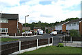
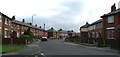
3
Newer section of Marlborough Avenue, Spring View
In the 1970s a massive clearance of terraced housing took place along the length of Warrington Road, and of some terraced streets at Lower Ince. The Council bought a newly-built private housing development to house many of the displaced families. People were moved in groups of neighbours from their old streets.
Image: © David Long
Taken: 24 Apr 2007
0.09 miles
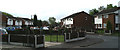
7
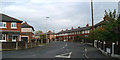
Marlvern Crescent from Marlborough Avenue, Spring View
Image: © David Long
Taken: 24 Apr 2007
0.11 miles
8
Hathaway Walk, Spring View
The rest of the roads on this estate were named after Stately Homes - but presumably this was named after Ann Hathaway's Cottage.
Image: © David Long
Taken: 21 Jun 2007
0.12 miles
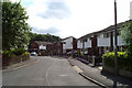
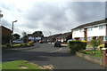
10
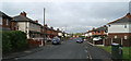
Looking west down Marlborough Avenue, Spring View
This was the original end of the Estate. Malvern Crescent goes off to the right beyond the car.
Image: © David Long
Taken: 24 Apr 2007
0.15 miles