IMAGES TAKEN NEAR TO
Warrington Road, WIGAN, WN3 4NF
Introduction
This page details the photographs taken nearby to Warrington Road, WN3 4NF by members of the Geograph project.
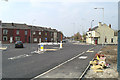
The Geograph project started in 2005 with the aim of publishing, organising and preserving representative images for every square kilometre of Great Britain, Ireland and the Isle of Man.

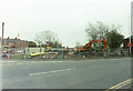
There are currently over 7.5m images from over14,400 individuals and you can help contribute to the project by visiting https://www.geograph.org.uk
Image Map
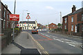
Images are licensed for reuse under creativecommons.org/licenses/by-sa/2.0
Notes
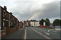
- Clicking on the map will re-center to the selected point.
- The higher the marker number, the further away the image location is from the centre of the postcode.
Image Listing (295 Images Found)
Images are licensed for reuse under creativecommons.org/licenses/by-sa/2.0
Image
Details
Distance
1
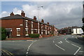
Out of sequence -1
Two rows of terraces along Warrington Road have been given sequential numbers outside the sequence for Warrington Road itself. This row is Rocky Bank Terrace, and is numbered 1-9, from the far end.
Image: © David Long
Taken: 14 Sep 2008
0.01 miles
2
Top deck, route 658-06
Westwood Terrace, Warrington Road.
Image: © David Long
Taken: 8 Jul 2008
0.01 miles
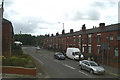
3
Deakin Street, Lower Ince
In front of the cars a concrete block marks one of the shafts of Crow Orchard pit. The other shaft lies behind the new houses on the right.
Image: © David Long
Taken: 14 Jul 2007
0.02 miles
4
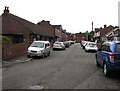
South along Banner Street, Lower Ince
On the south side of Warrington Road.
Image: © Jaggery
Taken: 23 Sep 2017
0.02 miles
5
Changing the lie of the land, no.2
The works to create the link road to the new Clinic, as seen from Warrington Road.
Image: © David Long
Taken: Unknown
0.02 miles
6
All changed
The new access road to the Clinic, now named Phoenix Way, at its junction with Warrington Road and Ince Green Lane, by the Black Diamond pub.
Image: © David Long
Taken: 21 Apr 2005
0.02 miles
7
"New Roundabout Ahead"
The new road junction to the Clinic seen from Warrington Road.
Image: © David Long
Taken: 21 Apr 2005
0.02 miles
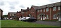
8

Warrington Road houses, Lower Ince
On the east side of the A573 Warrington Road.
Image: © Jaggery
Taken: 23 Sep 2017
0.03 miles
9
A chimney-pot of gold?
Rainbow on Warrington Road.
Image: © David Long
Taken: 11 Sep 2008
0.03 miles
10
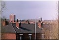
Up and away
Russell House multi-storey block and St. Patrick's RC Church in Scholes, as seen over the roofs of Rocky Bank Terrace on Warrington Road.
Image: © David Long
Taken: Unknown
0.04 miles