IMAGES TAKEN NEAR TO
Frederick Street, WIGAN, WN3 4JZ
Introduction
This page details the photographs taken nearby to Frederick Street, WN3 4JZ by members of the Geograph project.
The Geograph project started in 2005 with the aim of publishing, organising and preserving representative images for every square kilometre of Great Britain, Ireland and the Isle of Man.

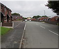
There are currently over 7.5m images from over14,400 individuals and you can help contribute to the project by visiting https://www.geograph.org.uk
Image Map
Images are licensed for reuse under creativecommons.org/licenses/by-sa/2.0
Notes
- Clicking on the map will re-center to the selected point.
- The higher the marker number, the further away the image location is from the centre of the postcode.
Image Listing (287 Images Found)
Images are licensed for reuse under creativecommons.org/licenses/by-sa/2.0
Image
Details
Distance
1

Independent Methodist Church, on Chapel Street, James Street, Lower Ince
Image: © David Long
Taken: 16 Nov 2005
0.01 miles
2

Westwood Independent Methodist Chapel
seen from the top of James Street, off Warrington Road
Image: © David Long
Taken: 24 Apr 2006
0.01 miles
3
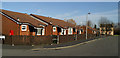
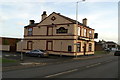
Frederick Street, Lower Ince
The street is actually on the line of the former William Street (q.v) with Frederick Street itself being the next one North, to the left. The cream building in the background was "The Little Rock", or "Rock Ferry" pub on Warrington Road. It is now "Vivo", an Italian restaurant. The homes are for pensioners, and there is a community centre nearby for them.
Image: © David Long
Taken: 23 Jan 2007
0.01 miles
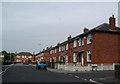
4
Autumn colours, Frederick Street, Ince
Autumn colours have begun to replace the greens of summer on the corner
of Frederick Street and Warrington Road in late September 2017.
Image: © Jaggery
Taken: 23 Sep 2017
0.02 miles
5
New houses on a corner of Ince-in-Makerfield
On the corner of Warrington Road and Frederick Street viewed in September 2017.
The houses are not in a Google Earth Street View taken three years earlier.
Image: © Jaggery
Taken: 23 Sep 2017
0.02 miles
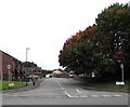
7
West along Frederick Street, Ince-in-Makerfield
Along Frederick Street towards Chapel Street from the corner of Warrington Road.
Image: © Jaggery
Taken: 23 Sep 2017
0.03 miles
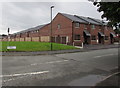
8
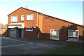
Westwood Grange, Chapel Street, Lower Ince
The Community Centre serving the residents of the nearby pensioners' bungalows.
Image: © David Long
Taken: 23 Jan 2007
0.03 miles
9
Things are hotting up
The former Rock Ferry pub (known as The Little Rock - a larger one over the road was The Big Rock), became an Italian Restaurant in 2006... closed in 2007, and is now a Curry House.
Image: © David Long
Taken: 4 Feb 2008
0.03 miles
10
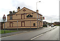
A new lease of life
The former Rock Ferry pub was converted into an Italian restaurant. A short-lived venture which lasted just over a year.
Image: © David Long
Taken: 25 Oct 2006
0.03 miles