IMAGES TAKEN NEAR TO
Furlong Close, WIGAN, WN2 5LH
Introduction
This page details the photographs taken nearby to Furlong Close, WN2 5LH by members of the Geograph project.
The Geograph project started in 2005 with the aim of publishing, organising and preserving representative images for every square kilometre of Great Britain, Ireland and the Isle of Man.

There are currently over 7.5m images from over14,400 individuals and you can help contribute to the project by visiting https://www.geograph.org.uk
Image Map
Images are licensed for reuse under creativecommons.org/licenses/by-sa/2.0
Notes
- Clicking on the map will re-center to the selected point.
- The higher the marker number, the further away the image location is from the centre of the postcode.
Image Listing (31 Images Found)
Images are licensed for reuse under creativecommons.org/licenses/by-sa/2.0
Image
Details
Distance

3

Tin tabernacle
Original Church of the Good Shepherd, Bamfurlong.
Image: © David Long
Taken: 22 Nov 2005
0.07 miles

5
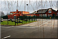
Abram Bryn Gate CP School
School and Zebra Crossing
Image: © Dave Green
Taken: 28 Jul 2008
0.09 miles
6
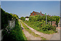
Public Footpath
Start of public footpath off Lily Lane, Bamfurlong
Image: © Dave Green
Taken: 28 Jul 2008
0.11 miles
7
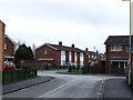
Junction of Winstanley Road and Enid Place, Bamfurlong
Image: © Gary Rogers
Taken: 19 Feb 2017
0.12 miles
8
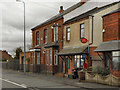
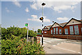
Bamfurlong Post Office
The post office and terraced houses on Lily Lane (A58), Banfurlong.
Image: © David Dixon
Taken: 23 Feb 2012
0.12 miles

