IMAGES TAKEN NEAR TO
Rawthey Gardens, WIGAN, WN2 5FL
Introduction
This page details the photographs taken nearby to Rawthey Gardens, WN2 5FL by members of the Geograph project.
The Geograph project started in 2005 with the aim of publishing, organising and preserving representative images for every square kilometre of Great Britain, Ireland and the Isle of Man.

There are currently over 7.5m images from over14,400 individuals and you can help contribute to the project by visiting https://www.geograph.org.uk
Image Map
Images are licensed for reuse under creativecommons.org/licenses/by-sa/2.0
Notes
- Clicking on the map will re-center to the selected point.
- The higher the marker number, the further away the image location is from the centre of the postcode.
Image Listing (8 Images Found)
Images are licensed for reuse under creativecommons.org/licenses/by-sa/2.0
Image
Details
Distance
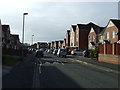
1
Blocked road, Mersey Road, Platt Bridge
Image: © Alex McGregor
Taken: 24 Jun 2011
0.09 miles
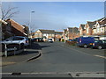
2
Blocked road, Mersey Road, Platt Bridge
Image: © Alex McGregor
Taken: 24 Jun 2011
0.10 miles
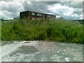
5
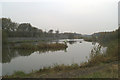
Tranquil beside the West Coast Main Line....
Image: © David Long
Taken: 22 Nov 2005
0.13 miles
6
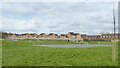
Children's play area
Off Stratton Drive, Platt Bridge
Image: © Kevin Waterhouse
Taken: 2 Apr 2024
0.20 miles
7
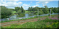
Gone Fishing fishery
Coarse fishing by the railway near Wigan. Viewed from a train heading to Manchester Airport.
Facebook: https://en-gb.facebook.com/pages/category/Outdoor---Sporting-Goods-Company/Gone-Fishing-1588828121171531/ .
Image: © Thomas Nugent
Taken: 6 Jul 2020
0.22 miles
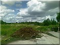
8
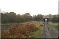
More abandoned railways
The continuation of the line under the milestone bridge is dimly visible to the left of the bridge carrying the track.
Image: © David Long
Taken: 22 Nov 2005
0.24 miles