IMAGES TAKEN NEAR TO
Heathlea, WIGAN, WN2 4TZ
Introduction
This page details the photographs taken nearby to Heathlea, WN2 4TZ by members of the Geograph project.
The Geograph project started in 2005 with the aim of publishing, organising and preserving representative images for every square kilometre of Great Britain, Ireland and the Isle of Man.

There are currently over 7.5m images from over14,400 individuals and you can help contribute to the project by visiting https://www.geograph.org.uk
Image Map
Images are licensed for reuse under creativecommons.org/licenses/by-sa/2.0
Notes
- Clicking on the map will re-center to the selected point.
- The higher the marker number, the further away the image location is from the centre of the postcode.
Image Listing (20 Images Found)
Images are licensed for reuse under creativecommons.org/licenses/by-sa/2.0
Image
Details
Distance
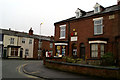
1
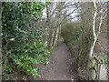
Hindley Green station (gone and largely forgotten)
The Manchester Exchange to Wigan North Western line opened in 1864 and closed in 1969.
Image: © S Parish
Taken: 1 Jan 2006
0.03 miles
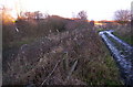
3
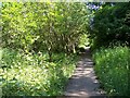
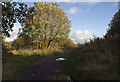
The low path, the route of a disused railway track
Image: © Ian Greig
Taken: 7 Oct 2011
0.05 miles
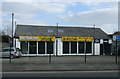
4
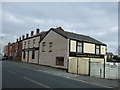
The site of Hindley Green station
The path follows the former platform of the station. The dismantled railway was the Wigan to Manchester line via Eccles
Image: © Raymond Knapman
Taken: 3 Jun 2011
0.05 miles
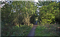
9
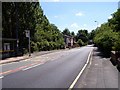
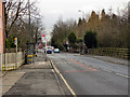
The A578 crosses the site of the railway bridge at Hindley Green
Image: © Raymond Knapman
Taken: 3 Jun 2011
0.10 miles