IMAGES TAKEN NEAR TO
Charlesworth Avenue, WIGAN, WN2 4NU
Introduction
This page details the photographs taken nearby to Charlesworth Avenue, WN2 4NU by members of the Geograph project.
The Geograph project started in 2005 with the aim of publishing, organising and preserving representative images for every square kilometre of Great Britain, Ireland and the Isle of Man.

There are currently over 7.5m images from over14,400 individuals and you can help contribute to the project by visiting https://www.geograph.org.uk
Image Map
Images are licensed for reuse under creativecommons.org/licenses/by-sa/2.0
Notes
- Clicking on the map will re-center to the selected point.
- The higher the marker number, the further away the image location is from the centre of the postcode.
Image Listing (11 Images Found)
Images are licensed for reuse under creativecommons.org/licenses/by-sa/2.0
Image
Details
Distance
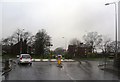
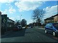
3

Mini-roundabout on the A577 at Hindley
Image: © Raymond Knapman
Taken: 3 Jun 2011
0.19 miles
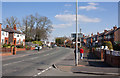
7
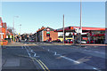
Atherton Road (A577)
The A577, Atherton Road, at Hindley, near Wigan.
Image: © David Dixon
Taken: 26 Mar 2012
0.20 miles
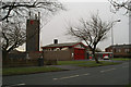
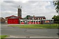
9
Hindley Fire Station
Hindley Fire Station on Borsdane Avenue.
Image: © David Dixon
Taken: 26 Mar 2012
0.22 miles
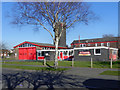
10
Hindley fire station
Hindley fire station, Borsdane Avenue, Hindley, Wigan, Greater Manchester, showing a different view from Image
Image: © Kevin Hale
Taken: 3 Jun 2009
0.23 miles