IMAGES TAKEN NEAR TO
Croyde Close, WIGAN, WN2 4NF
Introduction
This page details the photographs taken nearby to Croyde Close, WN2 4NF by members of the Geograph project.
The Geograph project started in 2005 with the aim of publishing, organising and preserving representative images for every square kilometre of Great Britain, Ireland and the Isle of Man.

There are currently over 7.5m images from over14,400 individuals and you can help contribute to the project by visiting https://www.geograph.org.uk
Image Map
Images are licensed for reuse under creativecommons.org/licenses/by-sa/2.0
Notes
- Clicking on the map will re-center to the selected point.
- The higher the marker number, the further away the image location is from the centre of the postcode.
Image Listing (6 Images Found)
Images are licensed for reuse under creativecommons.org/licenses/by-sa/2.0
Image
Details
Distance
1
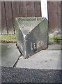
Old Boundary Marker by the A577, Atherton Road, Hindley Green
Parish Boundary Marker by the A577, in parish of Hindley (Wigan District), Atherton Road - 10m east of Carr Common Road, just before Tesco Garage, in pavement, against a fence.
Surveyed
Milestone Society National ID: LA_HINLEI01pb.
Image: © Milestone Society
Taken: Unknown
0.07 miles
4
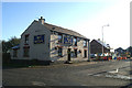
The Bull & Butcher, at Dangerous Corner, Westleigh
Image: © David Long
Taken: 17 Nov 2005
0.20 miles