
IMAGES TAKEN NEAR TO
Moss Lane, WIGAN, WN2 3TL
Introduction
This page details the photographs taken nearby to Moss Lane, WN2 3TL by members of the Geograph project.
The Geograph project started in 2005 with the aim of publishing, organising and preserving representative images for every square kilometre of Great Britain, Ireland and the Isle of Man.

There are currently over 7.5m images from over14,400 individuals and you can help contribute to the project by visiting https://www.geograph.org.uk
Image Map
Images are licensed for reuse under creativecommons.org/licenses/by-sa/2.0
Notes
- Clicking on the map will re-center to the selected point.
- The higher the marker number, the further away the image location is from the centre of the postcode.
Image Listing (28 Images Found)
Images are licensed for reuse under creativecommons.org/licenses/by-sa/2.0
Image
Details
Distance
1
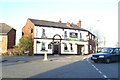
The Railway, pub on the corner of Liverpool Road (A58) and Moss Lane, Platt Bridge
Image: © David Long
Taken: 16 Nov 2005
0.03 miles
2
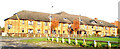
Arena Homes' Langton Court, Moss Lane, Platt Bridge
Image: © David Long
Taken: 16 Nov 2005
0.03 miles
3
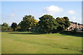
Shades of the past
Nestling among the trees beside Moss Lane, Platt Bridge, once stood Dower House Farm, a Grade 2 listed building. Sadly, no one loved it enough to ensure that it remained standing. It was demolished in 1997.
Image: © David Long
Taken: 9 Oct 2008
0.12 miles
4
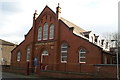
Platt Bridge Independent Methodist Church
On Liverpool Road (the A58), heading towards Hindley.
Image: © David Long
Taken: 24 Nov 2008
0.14 miles
5
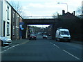
Liverpool Road passes under disused railway bridge
Image: © Colin Pyle
Taken: 29 Mar 2013
0.14 miles
6
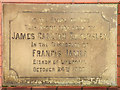
Foundation Stone, St Nathaniel's Church
St Nathaniel's Parish Church,on Church Road is Platt Bridge's main parish church.The foundation stone was laid 24th October 1903 by benefactor James Carlton Eckersley who funded the building.
The stone is beneath the west window of the building. (Image] for context).
Image: © David Dixon
Taken: 23 Feb 2012
0.15 miles
7
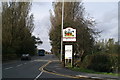
Brand new Geograph-03
The newly-erected sign on the boundary of Spring View, Ince-in-Makerfield.
Image: © David Long
Taken: 9 Oct 2008
0.15 miles
8
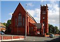
St. Nathaniel's church
St. Nathaniel's church Platt Bridge
Image: © Galatas
Taken: 15 Sep 2009
0.15 miles
9
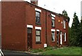
Dale Street, Spring View
This row, in 'Clinker Valley', are the last, or first, houses to the south of St Mary's Parish.
Image: © David Long
Taken: 14 Jul 2007
0.15 miles
10
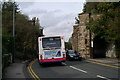
Tight fit
The abutments of the bridge over Warrington Road (A573), which once carried the Wigan-Atherton-Manchester line, which had a spur off to Bickershaw Colliery. It rather resembles an ancient gateway into a mediaeval town.
Image: © David Long
Taken: 9 Oct 2008
0.15 miles