IMAGES TAKEN NEAR TO
Manchester Road, WIGAN, WN2 3DR
Introduction
This page details the photographs taken nearby to Manchester Road, WN2 3DR by members of the Geograph project.
The Geograph project started in 2005 with the aim of publishing, organising and preserving representative images for every square kilometre of Great Britain, Ireland and the Isle of Man.

There are currently over 7.5m images from over14,400 individuals and you can help contribute to the project by visiting https://www.geograph.org.uk
Image Map
Images are licensed for reuse under creativecommons.org/licenses/by-sa/2.0
Notes
- Clicking on the map will re-center to the selected point.
- The higher the marker number, the further away the image location is from the centre of the postcode.
Image Listing (19 Images Found)
Images are licensed for reuse under creativecommons.org/licenses/by-sa/2.0
Image
Details
Distance
1

Barn conversion north of Manchester Road
Image: © Alex McGregor
Taken: 24 Jun 2011
0.02 miles
2
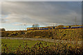
Train heading for Wigan
Taken from the footpath along the old Whelley Loop Line.
Image: © Dave Green
Taken: 29 Nov 2007
0.09 miles
3

La Cava
La Cava, Italian Restaurant.
Image: © Peter McDermott
Taken: 10 Sep 2016
0.11 miles
4
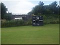
Hindley St. Peters Cricket Club - Scorebox
The scorers box and scoreboard at Hindley St. Peters CC ground just off Hurst Street.
Image: © BatAndBall
Taken: 4 Aug 2012
0.11 miles
6

Bridge carrying the Wigan-Manchester line over Manchester Road, the A577
Note the sign for Joy Mining Machinery sign - the former Gullick-Dobson Works, and the last vestiges of the coal industry in the area.
Image: © David Long
Taken: 4 Jun 2009
0.14 miles
7
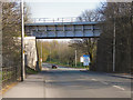
Rail Bridge, Manchester Road
The railway bridge crossing the A577, Manchester Road between Ince and Hindley.
Image: © David Dixon
Taken: 28 Mar 2012
0.15 miles
8
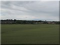
Field between Makerfield Way and the railway
Older maps call this area, including the part now covered by Morrison's supermarket and a housing estate in the background, The Square.
Image: © Stephen Craven
Taken: 2 Jul 2016
0.16 miles
9

Cycleway Gate
A dismantled railway has been turned into the Wigan cycleway - that may not be original, but this design of gate is, at least I have not seen it before.
Image: © David Lally
Taken: 25 Jun 2008
0.16 miles
10
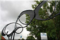
Strange Swirls
This unusual arch marks the entrance to a cycleway from Atherton Road, Hindley.
Image: © David Lally
Taken: 25 Jun 2008
0.16 miles