IMAGES TAKEN NEAR TO
Hemfield Court, Makerfield Way, WIGAN, WN2 2ER
Introduction
This page details the photographs taken nearby to Hemfield Court, Makerfield Way, WN2 2ER by members of the Geograph project.
The Geograph project started in 2005 with the aim of publishing, organising and preserving representative images for every square kilometre of Great Britain, Ireland and the Isle of Man.

There are currently over 7.5m images from over14,400 individuals and you can help contribute to the project by visiting https://www.geograph.org.uk
Image Map
Images are licensed for reuse under creativecommons.org/licenses/by-sa/2.0
Notes
- Clicking on the map will re-center to the selected point.
- The higher the marker number, the further away the image location is from the centre of the postcode.
Image Listing (5 Images Found)
Images are licensed for reuse under creativecommons.org/licenses/by-sa/2.0
Image
Details
Distance
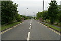
1

Schreiber Depot
The Geograph website is simply a sales promotion device for GPS navigation! (Remember where you heard it first, folks!). This is pretty confusing terrain. I couldn't believe I was where I was until I spotted the mobile phone mast - which is definitely at SD614055.
Image: © David Hignett
Taken: 12 Sep 2005
0.13 miles
2
Bridge over the Whelley Loop Line
The line was an avoiding line for the West Coast Main Line, by-passing Wigan. It left the WCML south of Springs Branch sheds, and rejoined it south of Standish. It is now a cycling route.
Image: © David Long
Taken: 3 Jun 2009
0.21 miles
3

Country Lane in Higher Ince
As towns spread out in the 19th century, the lanes in the surrounding countryside were gradually urbanised, or upgraded to serve the needs of the growing towns. Some, however, were spared development, and remain much as they were, such as this one, leading through fields and woods from an industrial estate in Higher Ince to Hindley.
Image: © David Long
Taken: 3 Jun 2009
0.21 miles
4
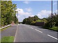
Makerfield Way bridges the dismantled whelley loop railway
Image: © Raymond Knapman
Taken: 3 Sep 2010
0.22 miles
5

Makerfield Way
Bridge carrying Makerfield Way across an old railway line.
Image: © Peter McDermott
Taken: 10 Sep 2016
0.22 miles