IMAGES TAKEN NEAR TO
Manchester Road, WIGAN, WN2 2DJ
Introduction
This page details the photographs taken nearby to Manchester Road, WN2 2DJ by members of the Geograph project.
The Geograph project started in 2005 with the aim of publishing, organising and preserving representative images for every square kilometre of Great Britain, Ireland and the Isle of Man.

There are currently over 7.5m images from over14,400 individuals and you can help contribute to the project by visiting https://www.geograph.org.uk
Image Map
Images are licensed for reuse under creativecommons.org/licenses/by-sa/2.0
Notes
- Clicking on the map will re-center to the selected point.
- The higher the marker number, the further away the image location is from the centre of the postcode.
Image Listing (35 Images Found)
Images are licensed for reuse under creativecommons.org/licenses/by-sa/2.0
Image
Details
Distance

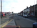
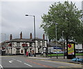
6
Manchester Road (A577)
The A573 (Manchester Road) between Hindley and Ince.
Image: © David Dixon
Taken: 28 Mar 2012
0.04 miles
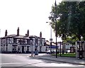
7
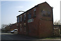
The Engineer's Arms, Engineer Street, Higher Ince
Image: © David Long
Taken: 18 Mar 2009
0.05 miles
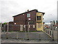
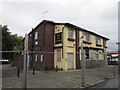
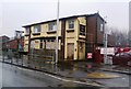
8

The ex Fox Tavern
The floral display contrasts sharply with the boarded up tavern on Manchester Road
Image: © Raymond Knapman
Taken: 3 Sep 2010
0.05 miles