IMAGES TAKEN NEAR TO
Brookbridge Road, WIGAN, WN2 2BQ
Introduction
This page details the photographs taken nearby to Brookbridge Road, WN2 2BQ by members of the Geograph project.
The Geograph project started in 2005 with the aim of publishing, organising and preserving representative images for every square kilometre of Great Britain, Ireland and the Isle of Man.

There are currently over 7.5m images from over14,400 individuals and you can help contribute to the project by visiting https://www.geograph.org.uk
Image Map
Images are licensed for reuse under creativecommons.org/licenses/by-sa/2.0
Notes
- Clicking on the map will re-center to the selected point.
- The higher the marker number, the further away the image location is from the centre of the postcode.
Image Listing (8 Images Found)
Images are licensed for reuse under creativecommons.org/licenses/by-sa/2.0
Image
Details
Distance
1
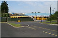
Yellow school buses at First's Wigan depot
In an attempt to make travelling to school on a bus 'cool', as opposed to having your ear bent by a parent as they drive you in the family car to school and back, yellow school buses, in imitation of the iconic US school bus, are increasingly seen on our roads. It seems a bit wasteful - the buses in regular fleet colours also do duty on regular stage carriage routes, but the yellow buses sit idle during the school day. Seems at variance with the aim of getting pupils to use school buses as an environmental measure.
Image: © David Long
Taken: 4 Jun 2009
0.03 miles
2
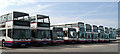
Waiting for the bell - school buses in First's depot in Wigan
Most local stage carriage services now use single-decker buses, but high capacity vehicles are still required for the morning and afternoon schools contracts. Buses from here serve schools in the local area and also West Lancashire, which means there's a lot of dead mileage being run between the depot and the schools.
Image: © David Long
Taken: 4 Jun 2009
0.05 miles
3
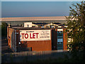
Wigan Enterprise Park
Wigan Enterprise Park in Ince, Wigan.
Image: © Peter McDermott
Taken: 23 Jul 2014
0.05 miles
4
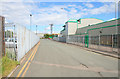
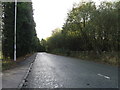
Dobson Park Way
Ince-in-Makerfield. On the right is a large food factory - no indication of what they actually make.
Image: © David Lally
Taken: 19 Jun 2008
0.16 miles
5
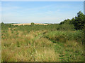
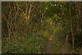
Amberswood Community Woodland
I'm not quite sure what "Community Woodland" is, but it has been sponsored by the Co-Operative Bank. Maybe five or six years ago this was the Corporation Refuse Tip!
Image: © David Hignett
Taken: 12 Sep 2005
0.17 miles
6
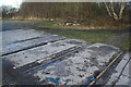
Springs Branch
Remaining tracks of the Springs Branch just off the bottom of Laburnum Ave. Springs Branch originally ran up to Wigan Iron Works, known as "Top Place". The branch opened in 1838 and was finally lifted in the late 1990's.
Image: © David Ashcroft
Taken: 12 Jan 2013
0.19 miles