IMAGES TAKEN NEAR TO
Tarnbrook Drive, WIGAN, WN2 1RJ
Introduction
This page details the photographs taken nearby to Tarnbrook Drive, WN2 1RJ by members of the Geograph project.
The Geograph project started in 2005 with the aim of publishing, organising and preserving representative images for every square kilometre of Great Britain, Ireland and the Isle of Man.

There are currently over 7.5m images from over14,400 individuals and you can help contribute to the project by visiting https://www.geograph.org.uk
Image Map
Images are licensed for reuse under creativecommons.org/licenses/by-sa/2.0
Notes
- Clicking on the map will re-center to the selected point.
- The higher the marker number, the further away the image location is from the centre of the postcode.
Image Listing (52 Images Found)
Images are licensed for reuse under creativecommons.org/licenses/by-sa/2.0
Image
Details
Distance
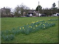
2
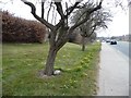
Dwarf daffodils along Wigan Road, Aspull
A sign of spring on the B5238.
Image: © Christine Johnstone
Taken: 10 Apr 2013
0.11 miles
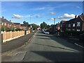
3
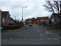
Wigan Road (B5238), Aspull
Heading south west.
Image: © JThomas
Taken: 28 Mar 2015
0.12 miles
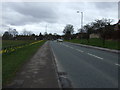
4
Holly Road, Aspull
Looking north from Wigan Road (B5238).
Image: © JThomas
Taken: 28 Mar 2015
0.12 miles
5
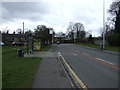
Bus stop and shelter on Wigan Road (B5238), Aspull
Image: © JThomas
Taken: 28 Mar 2015
0.15 miles
7
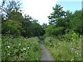
Path on route of former mineral railway
The path follows the route of the railway to Higher Lane. This view is near the start of the path off Manor Grove.
Image: © Kevin Waterhouse
Taken: 23 Jul 2024
0.16 miles
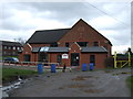
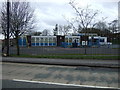
9
Aspull Methodist Church
On Crawford Street, off the Wigan Road.
Image: © Christine Johnstone
Taken: 10 Apr 2013
0.16 miles