IMAGES TAKEN NEAR TO
Red Rock Lane, WIGAN, WN2 1LX
Introduction
This page details the photographs taken nearby to Red Rock Lane, WN2 1LX by members of the Geograph project.
The Geograph project started in 2005 with the aim of publishing, organising and preserving representative images for every square kilometre of Great Britain, Ireland and the Isle of Man.

There are currently over 7.5m images from over14,400 individuals and you can help contribute to the project by visiting https://www.geograph.org.uk
Image Map
Images are licensed for reuse under creativecommons.org/licenses/by-sa/2.0
Notes
- Clicking on the map will re-center to the selected point.
- The higher the marker number, the further away the image location is from the centre of the postcode.
Image Listing (9 Images Found)
Images are licensed for reuse under creativecommons.org/licenses/by-sa/2.0
Image
Details
Distance
1
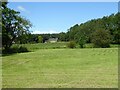
View over fields to Winstanley House
Seen from Pendlebury Lane
Image: © Kevin Waterhouse
Taken: 23 Jul 2024
0.14 miles
2
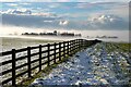
Bawk House Farm
The woodland around Bawk House Farm shrouded in mist.
Image: © Peter McDermott
Taken: 30 Dec 2020
0.16 miles
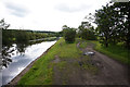
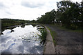
5
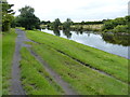
Towpath along the Leeds and Liverpool Canal
Image: © Mat Fascione
Taken: 16 Jul 2016
0.23 miles
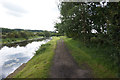
6
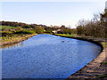
Leeds & Liverpool Canal
The Leeds & Liverpool Canal, south of Red Rock.
Image: © David Dixon
Taken: 8 Apr 2011
0.24 miles
7
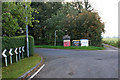
At Red Rock Lodge, one of the approaches to Haigh Hall
Image: © Ian Greig
Taken: 8 Oct 2010
0.24 miles
9
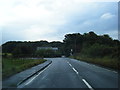
School Lane turns left into Meadow Pit Lane
Image: © Colin Pyle
Taken: 26 Sep 2012
0.25 miles