IMAGES TAKEN NEAR TO
Wigan Road, WIGAN, WN2 1DH
Introduction
This page details the photographs taken nearby to Wigan Road, WN2 1DH by members of the Geograph project.
The Geograph project started in 2005 with the aim of publishing, organising and preserving representative images for every square kilometre of Great Britain, Ireland and the Isle of Man.

There are currently over 7.5m images from over14,400 individuals and you can help contribute to the project by visiting https://www.geograph.org.uk
Image Map
Images are licensed for reuse under creativecommons.org/licenses/by-sa/2.0
Notes
- Clicking on the map will re-center to the selected point.
- The higher the marker number, the further away the image location is from the centre of the postcode.
Image Listing (36 Images Found)
Images are licensed for reuse under creativecommons.org/licenses/by-sa/2.0
Image
Details
Distance
1
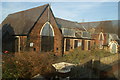
St John the Baptist CE Junior and Infant School, New Springs, Wigan
Image: © Gary Rogers
Taken: 12 Feb 2015
0.00 miles
2
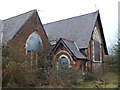
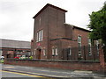
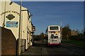
View from the top deck-23
Where the four lines meet! The oldest part of the former St John's CofE School lies waiting for its next life. It would be a shame if it ended up being demolished. Sadly, that's happened to many Wigan Geographs in the past.
Image: © David Long
Taken: 15 Nov 2007
0.02 miles
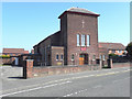
4
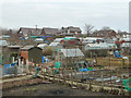
Minewater Treatment Plant
I would love to explain what a "Sough" is, but all I can find out is that it's something to do with Mine drainage. This place takes nasty polluted water and makes it better. Tim Livesey has now written to advise that a Sough acts a bit like a field drain dug under otherwise sodden mineworkings.
Image: © David Hignett
Taken: 7 Sep 2005
0.11 miles
5
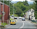
View from the top deck-22
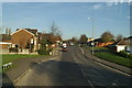
The road changes name again - from Whelley to Wigan Road (of which there are no less than 12 in the Borough, plus two Wigan Lanes). Cale Lane comes in from the right at the lights.
Image: © David Long
Taken: 15 Nov 2007
0.11 miles
7
Holy Family Catholic Church
The Holy Family Catholic Church on Cale Lane, New Springs.
Image: © David Dixon
Taken: 28 Mar 2012
0.14 miles
8
View from the top deck-last stop
It really should be 'View of the back end of a bus', but that would have put it outside the series, and followers might have wondered what happened next. We are now just below the level of the canal, which has been brought up to this level via the 21 locks of the Wigan Flight - a rise of 200 feet.
Image: © David Long
Taken: 15 Nov 2007
0.15 miles
9
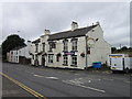
Crown Hotel on Wigan Road in New Springs
Image: © Mat Fascione
Taken: 16 Jul 2016
0.17 miles