IMAGES TAKEN NEAR TO
Camberwell Crescent, WIGAN, WN2 1AT
Introduction
This page details the photographs taken nearby to Camberwell Crescent, WN2 1AT by members of the Geograph project.
The Geograph project started in 2005 with the aim of publishing, organising and preserving representative images for every square kilometre of Great Britain, Ireland and the Isle of Man.

There are currently over 7.5m images from over14,400 individuals and you can help contribute to the project by visiting https://www.geograph.org.uk
Image Map
Images are licensed for reuse under creativecommons.org/licenses/by-sa/2.0
Notes
- Clicking on the map will re-center to the selected point.
- The higher the marker number, the further away the image location is from the centre of the postcode.
Image Listing (6 Images Found)
Images are licensed for reuse under creativecommons.org/licenses/by-sa/2.0
Image
Details
Distance
1

Whelley Loop Line - Roundhouse Junction
To the Kirkless ironworks.
http://www.wiganworld.co.uk/album/photo.php?opt=5&id=5443&gallery=Whelley&offset=0
Image: © David Ashcroft
Taken: 9 Apr 2010
0.13 miles
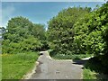
2

Footpaths at Whelley
Following the route of dismantled railway lines.
Image: © Gary Rogers
Taken: 12 Feb 2015
0.13 miles
3
Cycle path following route of former railway
On the former Lancashire Union line at the site of a former underpass for the path from the right to go under the railway
Image: © Kevin Waterhouse
Taken: 29 May 2023
0.14 miles

5

Footpath to Camberwell Crescent, Whelley
From the path of the old railway line.
Image: © Gary Rogers
Taken: 12 Feb 2015
0.19 miles
6

Whelley Loop Line
Once a railway, now a nice footpath.
Image: © David Ashcroft
Taken: 9 Apr 2010
0.19 miles