IMAGES TAKEN NEAR TO
Wellington Street, WIGAN, WN1 3SB
Introduction
This page details the photographs taken nearby to Wellington Street, WN1 3SB by members of the Geograph project.
The Geograph project started in 2005 with the aim of publishing, organising and preserving representative images for every square kilometre of Great Britain, Ireland and the Isle of Man.

There are currently over 7.5m images from over14,400 individuals and you can help contribute to the project by visiting https://www.geograph.org.uk
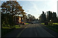
Image Map
Images are licensed for reuse under creativecommons.org/licenses/by-sa/2.0
Notes
- Clicking on the map will re-center to the selected point.
- The higher the marker number, the further away the image location is from the centre of the postcode.
Image Listing (101 Images Found)
Images are licensed for reuse under creativecommons.org/licenses/by-sa/2.0
Image
Details
Distance
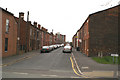
1
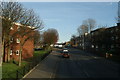
View from the top deck-11
Up the brew at Scholes. Once tightly packed with tiny terraced houses and lodging houses.
Image: © David Long
Taken: 15 Nov 2007
0.03 miles
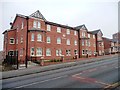
4
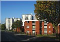
Contrasting flats in Scholes, Wigan
Newer low-rise at the top of the hill, older high-rise at the bottom.
Image: © Christine Johnstone
Taken: 6 Mar 2013
0.06 miles
5
40 Scholes, Wigan
An unmapped new development, south of Morriss Street.
Image: © Christine Johnstone
Taken: 6 Mar 2013
0.06 miles
6
View from the top deck-10
Junction of School Lane with Warrington Lane, with Millgate to the right, and Scholes to the left. The multi-storey is Brook House. The Salvation Army Citadel is on the left.
Image: © David Long
Taken: 15 Nov 2007
0.07 miles
7
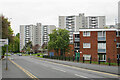
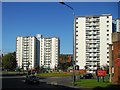
Scholes Village housing blocks
The social housing high-rise blocks have been fairly recently refurbished.
Image: © Bill Boaden
Taken: 28 Apr 2022
0.08 miles
8
View from the top deck-12
On Scholes. Scene of a violent murder a couple of years back when the proprietor of a Chinese Chip Shop in the second block on the right was murdered by a gang of youngsters. The multi-storey is Boyswell House.
Image: © David Long
Taken: 15 Nov 2007
0.09 miles
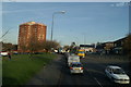
10
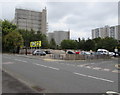
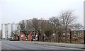
Multistorey flats, Wigan
Viewed across the A49 Harrogate Street.
Image: © Jaggery
Taken: 23 Sep 2017
0.12 miles