IMAGES TAKEN NEAR TO
Warrington Lane, WIGAN, WN1 3RP
Introduction
This page details the photographs taken nearby to Warrington Lane, WN1 3RP by members of the Geograph project.
The Geograph project started in 2005 with the aim of publishing, organising and preserving representative images for every square kilometre of Great Britain, Ireland and the Isle of Man.

There are currently over 7.5m images from over14,400 individuals and you can help contribute to the project by visiting https://www.geograph.org.uk
Image Map
Images are licensed for reuse under creativecommons.org/licenses/by-sa/2.0
Notes
- Clicking on the map will re-center to the selected point.
- The higher the marker number, the further away the image location is from the centre of the postcode.
Image Listing (220 Images Found)
Images are licensed for reuse under creativecommons.org/licenses/by-sa/2.0
Image
Details
Distance
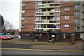
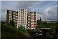
1
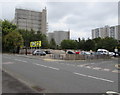
Multistorey flats, Wigan
Viewed across the A49 Harrogate Street.
Image: © Jaggery
Taken: 23 Sep 2017
0.01 miles
3
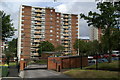
Scholes Village -03 Woodcock House
In order to make the flats more attractive to long-term tenants the open space around has been landscaped to include more parking, and has been fenced off to make the flats and the car parks more secure. Douglas House can be seen to the left, and Derby House to the right of the block.
Image: © David Long
Taken: 23 Jun 2008
0.02 miles
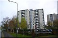
4
Scholes Village -02 Brook House
A pub, The Waterwheel, takes up the ground floor of the most westerly block, which must be an unusual feature for such a block of flats. It has been vacant for some years. Residents in the flats are apprehensive about what will happen when it has been auctioned off.
Image: © David Long
Taken: 23 Jun 2008
0.04 miles
5
Now a clip joint?
The pub beneath Brook House, one of Wigan's multi-storey blocks just south of the town centre in Scholes, has been closed for some time. It recently re-opened as a hairdressers... and last weekend (December 21st 2008) it had a grand re-opening as a pub. Whether the neighbours who live above are pleased remains to be seen.
Image: © David Long
Taken: 23 Dec 2008
0.05 miles
6
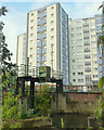
Flow control steelwork on River Douglas, Millgate, Wigan
Image: © Gary Rogers
Taken: 22 Sep 2015
0.05 miles
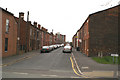
8
Brooklands Street, Scholes
The next road down from Spring Street.
Image: © David Long
Taken: 16 Mar 2007
0.07 miles
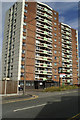
9
Scholes Village -01 Douglas House
Six 13-storey blocks of flats dominate the banks of the Douglas River south of Wigan Town Centre. Five are south of the river, but this one sits on its northern bank. There is a programme of refurbishment and landscaping under way to try to keep them occupied.
Image: © David Long
Taken: 23 Jun 2008
0.07 miles
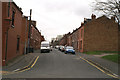
10
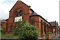
Their ship has sailed.
The Sea Cadets have long abandoned this former non-conformist chapel on the junction of Warrington Lane and Brookhouse Terrace. What fate awaits it now?
Image: © David Long
Taken: 23 Jun 2008
0.08 miles