IMAGES TAKEN NEAR TO
Kelway Terrace, WIGAN, WN1 3NX
Introduction
This page details the photographs taken nearby to Kelway Terrace, WN1 3NX by members of the Geograph project.
The Geograph project started in 2005 with the aim of publishing, organising and preserving representative images for every square kilometre of Great Britain, Ireland and the Isle of Man.

There are currently over 7.5m images from over14,400 individuals and you can help contribute to the project by visiting https://www.geograph.org.uk
Image Map
Images are licensed for reuse under creativecommons.org/licenses/by-sa/2.0
Notes
- Clicking on the map will re-center to the selected point.
- The higher the marker number, the further away the image location is from the centre of the postcode.
Image Listing (19 Images Found)
Images are licensed for reuse under creativecommons.org/licenses/by-sa/2.0
Image
Details
Distance
3
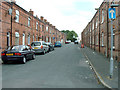
Ellis Street
One of the relatively few remaining streets of terraced houses left in the North West.
Image: © David Hignett
Taken: 7 Sep 2005
0.12 miles
5
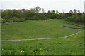
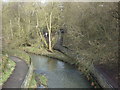
Redundant dam on the River Douglas
The river now flows straight under the dam in a controlled fashion.
Image: © Bill Boaden
Taken: 28 Apr 2022
0.16 miles
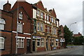
6
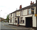
The pubs of Wigan Lane-04
The Millstone.
Image: © David Long
Taken: 23 Jun 2008
0.17 miles
7
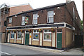
The pubs of Wigan Lane-03
The Fox & Goose.
Image: © David Long
Taken: 23 Jun 2008
0.18 miles
8
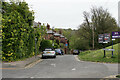
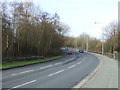
Coppull Lane
Dropping down into the valley of the River Douglas.
Image: © Bill Boaden
Taken: 28 Apr 2022
0.18 miles
9

The pubs of Wigan Lane-04A
A bit of a favourite....
Image: © David Long
Taken: 23 Jun 2008
0.20 miles
10
The pubs of Wigan Lane-05
The Bowling Green.
Image: © David Long
Taken: 23 Jun 2008
0.23 miles