IMAGES TAKEN NEAR TO
Platt Lane, WIGAN, WN1 2XQ
Introduction
This page details the photographs taken nearby to Platt Lane, WN1 2XQ by members of the Geograph project.
The Geograph project started in 2005 with the aim of publishing, organising and preserving representative images for every square kilometre of Great Britain, Ireland and the Isle of Man.

There are currently over 7.5m images from over14,400 individuals and you can help contribute to the project by visiting https://www.geograph.org.uk
Image Map
Images are licensed for reuse under creativecommons.org/licenses/by-sa/2.0
Notes
- Clicking on the map will re-center to the selected point.
- The higher the marker number, the further away the image location is from the centre of the postcode.
Image Listing (7 Images Found)
Images are licensed for reuse under creativecommons.org/licenses/by-sa/2.0
Image
Details
Distance
2
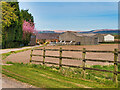
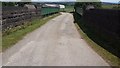
Talbot House Farm
This is the main entrance to the farm.
Image: © Bradley Michael
Taken: 3 Jul 2015
0.03 miles
3
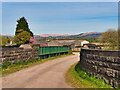
Hampsons Bridge at Standish
Bridge CGJ5/66, (Hampsons at Standish) carrying the track to Talbot House Farm over the railway line.
Image: © David Dixon
Taken: 23 Apr 2021
0.10 miles
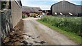
4
Bridge leading to Talbot House Farm
The railway underneath the bridge links Preston to Wigan.
Image: © Bradley Michael
Taken: 3 Jul 2015
0.11 miles
5
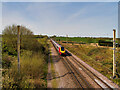
Express Going Through
A Virgin Express train heading north on the main line past Standish.
Image: © David Dixon
Taken: 23 Apr 2021
0.11 miles
6
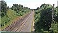
Railway line, Standish
This is how it appears looking from an overhead bridge connecting Talbot House Farm to local tracks.
Image: © Bradley Michael
Taken: 3 Jul 2015
0.12 miles