IMAGES TAKEN NEAR TO
Wessex Close, WIGAN, WN1 2TJ
Introduction
This page details the photographs taken nearby to Wessex Close, WN1 2TJ by members of the Geograph project.
The Geograph project started in 2005 with the aim of publishing, organising and preserving representative images for every square kilometre of Great Britain, Ireland and the Isle of Man.

There are currently over 7.5m images from over14,400 individuals and you can help contribute to the project by visiting https://www.geograph.org.uk
Image Map
Images are licensed for reuse under creativecommons.org/licenses/by-sa/2.0
Notes
- Clicking on the map will re-center to the selected point.
- The higher the marker number, the further away the image location is from the centre of the postcode.
Image Listing (24 Images Found)
Images are licensed for reuse under creativecommons.org/licenses/by-sa/2.0
Image
Details
Distance
1
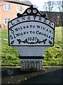
Old Milepost by the A5106, Chorley Road, Standish parish
Cast iron post by the A5106, in parish of STANDISH (WIGAN District), Chorley Road; Worthington; opposite junction with Devon Drive, on grassed area, on East side of road. Wigan fan iron casting, erected by the Wigan & Preston (south of Yarrow) turnpike trust in the 19th century.
Inscription reads:-
LANGTREE.
3 MILES TO WIGAN.
5¼ MILES TO CHORLEY.
1837
Maker:-
HAIGH FOUNDRY
Grade II listed.
List Entry Number: 1228467 https://historicengland.org.uk/listing/the-list/list-entry/1228467
Milestone Society National ID: LA_WGCY03.
Image: © M Faherty
Taken: 23 Aug 2008
0.05 miles
2
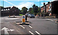
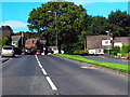
Chorley Road/Rectory lane Junction
Mini-roundabout at the junction of Chorley Road (A5106) and Rectory Lane (B5239), Standish.
Image: © David Dixon
Taken: 25 Sep 2010
0.07 miles
5
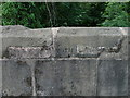
Old Boundary Marker by the A5106, Chorley Road, Standish Parish
Parish Boundary Marker by the A5106, in parish of Standish (Wigan District), Chorley Road, Worthington, South West parapet of bridge, 50m North of junction with Rectory Lane.
Inscription defaced.
Surveyed
Milestone Society National ID: LA_WGCY03pb
Image: © Milestone Society
Taken: Unknown
0.09 miles
7
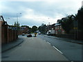
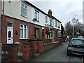
Chorley Road nearing Rectory Road junction
Image: © Colin Pyle
Taken: 26 Sep 2012
0.09 miles
8
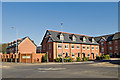
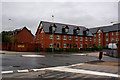
Worthington Park
On the site of Wigan's old Bleachworks
Image: © Dave Green
Taken: 13 Feb 2008
0.10 miles
9
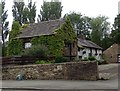
Manor House, Worthington
Situated on Chorley Road, the house was built in C17 and is Grade II* listed.
Image: © philandju
Taken: 30 Jul 2019
0.11 miles
10
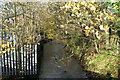
The boundary of the Hundreds of Leyland and West Derby
The River Douglas often causes flooding down in Wigan itself. Just visible across the stream, with a grey box on the left-hand bank, is what appears to be a device for measuring its levels up here to give warning down below.
Image: © David Long
Taken: 14 Nov 2008
0.12 miles