IMAGES TAKEN NEAR TO
Chorley Road, WIGAN, WN1 2SS
Introduction
This page details the photographs taken nearby to Chorley Road, WN1 2SS by members of the Geograph project.
The Geograph project started in 2005 with the aim of publishing, organising and preserving representative images for every square kilometre of Great Britain, Ireland and the Isle of Man.

There are currently over 7.5m images from over14,400 individuals and you can help contribute to the project by visiting https://www.geograph.org.uk
Image Map
Images are licensed for reuse under creativecommons.org/licenses/by-sa/2.0
Notes
- Clicking on the map will re-center to the selected point.
- The higher the marker number, the further away the image location is from the centre of the postcode.
Image Listing (26 Images Found)
Images are licensed for reuse under creativecommons.org/licenses/by-sa/2.0
Image
Details
Distance
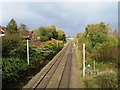
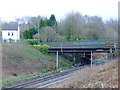
1
London to Glasgow railway
Taken from the A5106 bridge looking north
Image: © Alexander P Kapp
Taken: 2 Sep 2008
0.04 miles
2
Railway Bridge on A5106 Chorley Road at Boar's Head
Image: © Gary Rogers
Taken: 4 Mar 2017
0.08 miles
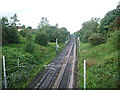
3
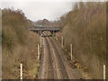
Railway at Boar's Head
The bridge at Chorley Road (A5106), seen from the bridge at Wigan Lane (A49).
Image: © David Dixon
Taken: 22 Feb 2013
0.08 miles
4
A5106 Bridge over railway at Boar's Head
Image: © Gary Rogers
Taken: 4 Mar 2017
0.09 miles
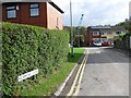
5
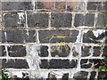
Recently used Ordnance Survey benchmark
Image: © Alex McGregor
Taken: 21 Oct 2014
0.09 miles
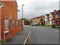
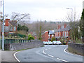
7
Bridge over railway, Water Drive, Boar's Head
Image: © Gary Rogers
Taken: 4 Mar 2017
0.10 miles