IMAGES TAKEN NEAR TO
Hall Lane, WIGAN, WN1 2SQ
Introduction
This page details the photographs taken nearby to Hall Lane, WN1 2SQ by members of the Geograph project.
The Geograph project started in 2005 with the aim of publishing, organising and preserving representative images for every square kilometre of Great Britain, Ireland and the Isle of Man.

There are currently over 7.5m images from over14,400 individuals and you can help contribute to the project by visiting https://www.geograph.org.uk
Image Map
Images are licensed for reuse under creativecommons.org/licenses/by-sa/2.0
Notes
- Clicking on the map will re-center to the selected point.
- The higher the marker number, the further away the image location is from the centre of the postcode.
Image Listing (7 Images Found)
Images are licensed for reuse under creativecommons.org/licenses/by-sa/2.0
Image
Details
Distance
1
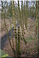
Whelley Loop Line
The Whelley Loop line where it passes beneath Hall Lane. A lone telegraph pole remains in the trees.
Image: © David Ashcroft
Taken: 13 Feb 2010
0.08 miles
2
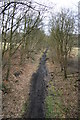
Whelley Loop Line
The Whelley Loop Line where it passed beneath Hall Lane.
Image: © David Ashcroft
Taken: 13 Feb 2010
0.12 miles
3
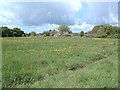
Buttercup Meadow
Taken from the footpath that runs parallel with the old railway line close to the woods and looking north west across the meadow towards the very nice houses!
Image: © Gary Rogers
Taken: 9 May 2005
0.14 miles
4
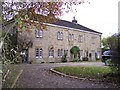
The Receptacle, former almshouses off Hall Lane
This building was a group of Haigh estate almshouses, built in 1772. https://historicengland.org.uk/listing/the-list/list-entry/1228264
Image: © Raymond Knapman
Taken: 5 Nov 2008
0.17 miles
5
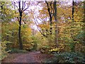
Awesome Autumn
Colourful autumn foliage in Haigh Lower Plantations viewed from track on northern edge
Image: © Raymond Knapman
Taken: 5 Nov 2008
0.20 miles
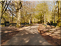
6
Bridge over disused "Whelley Loop" railway line
View from Haigh country park
Image: © Raymond Knapman
Taken: 5 Nov 2008
0.25 miles
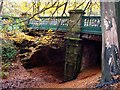
7
Haigh Country Park, Bridge over the Whelley Loop Line
The bridge between the Lower and Middle Plantations, crossing the (now dismantled) Whelley Loop Line which was opened in 1869 by the Lancashire Union Railway and used mainly for freight traffic.
The bridge was built in 1883-4; it is a Grade II listed building.
Image: © David Dixon
Taken: 2 May 2013
0.25 miles