IMAGES TAKEN NEAR TO
Woodlands Park Close, WIGAN, WN1 2SD
Introduction
This page details the photographs taken nearby to Woodlands Park Close, WN1 2SD by members of the Geograph project.
The Geograph project started in 2005 with the aim of publishing, organising and preserving representative images for every square kilometre of Great Britain, Ireland and the Isle of Man.

There are currently over 7.5m images from over14,400 individuals and you can help contribute to the project by visiting https://www.geograph.org.uk
Image Map
Images are licensed for reuse under creativecommons.org/licenses/by-sa/2.0
Notes
- Clicking on the map will re-center to the selected point.
- The higher the marker number, the further away the image location is from the centre of the postcode.
Image Listing (15 Images Found)
Images are licensed for reuse under creativecommons.org/licenses/by-sa/2.0
Image
Details
Distance
2
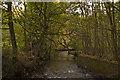
The River Douglas from the foot of Sicklefield
Image: © Ian Greig
Taken: 17 Oct 2010
0.11 miles
4
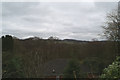
Over the hedge, Broomhey Avenue
Haigh Hall is visible in the distance.
Image: © David Long
Taken: 21 Feb 2009
0.16 miles
9
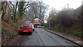
A49, Thorn Hill
Heading northwards out of Wigan.
Image: © Richard Webb
Taken: 17 Apr 2016
0.21 miles