IMAGES TAKEN NEAR TO
Wigan Lane, WIGAN, WN1 2NW
Introduction
This page details the photographs taken nearby to Wigan Lane, WN1 2NW by members of the Geograph project.
The Geograph project started in 2005 with the aim of publishing, organising and preserving representative images for every square kilometre of Great Britain, Ireland and the Isle of Man.

There are currently over 7.5m images from over14,400 individuals and you can help contribute to the project by visiting https://www.geograph.org.uk
Image Map
Images are licensed for reuse under creativecommons.org/licenses/by-sa/2.0
Notes
- Clicking on the map will re-center to the selected point.
- The higher the marker number, the further away the image location is from the centre of the postcode.
Image Listing (22 Images Found)
Images are licensed for reuse under creativecommons.org/licenses/by-sa/2.0
Image
Details
Distance
2

Cottage architecture
This florists and coffee shop won an award from Wigan's Civic Trust for the quality of its conversion. It was formerly a public lavatory.
Image: © David Long
Taken: 23 Jun 2008
0.05 miles
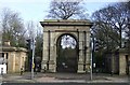
3
Gate, Haigh Park
Entrance at Marylebone on the A49.
Image: © Richard Webb
Taken: 17 Apr 2016
0.06 miles
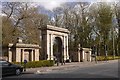
4
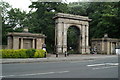
Gateway and lodges to Haigh Hall Park
The arch and lodges are an entrance to Haigh Hall Park and date from around 1840, they are Grade II* listed, see: https://historicengland.org.uk/listing/the-list/list-entry/1384570
Image: © Philip Halling
Taken: 24 Jun 2019
0.06 miles
5
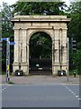
Arch entrance to Haigh Hall Park
The arch entrance to Haigh Hall Park dates from around 1840, and is Grade II* listed, see: https://historicengland.org.uk/listing/the-list/list-entry/1384570
Image: © Philip Halling
Taken: 24 Jun 2019
0.06 miles
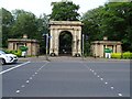
6
The Plantation Gates
To Haigh Hall, Golf Club, and Country Park.
Image: © David Long
Taken: 23 Jun 2008
0.06 miles
8

No Change Given
No ticket or refund either
Image: © Ian Greig
Taken: 20 Apr 2010
0.07 miles
9
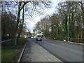
Wigan Lane outside the Royal Albert Edward Infirmary
Image: © Ian Greig
Taken: 20 Apr 2010
0.07 miles
10
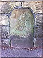
Old Milestone by the A49, Wigan Lane, Wigan parish
Carved stone post by the A49, in parish of WIGAN (WIGAN District), Wigan Lane; opposite The Hollies, leading to Woodlands, built into Infirmary wall, on West side of road. Stone post erected by the Wigan & Preston (south of Yarrow) turnpike trust in the 19th century.
Inscription unknown.
Grade II listed.
List Entry Number: 1384573 https://historicengland.org.uk/listing/the-list/list-entry/1384573
Milestone Society National ID: LA_WGPS01
Image: © M Faherty
Taken: Unknown
0.07 miles