IMAGES TAKEN NEAR TO
Rodney Street, WIGAN, WN1 1DG
Introduction
This page details the photographs taken nearby to Rodney Street, WN1 1DG by members of the Geograph project.
The Geograph project started in 2005 with the aim of publishing, organising and preserving representative images for every square kilometre of Great Britain, Ireland and the Isle of Man.

There are currently over 7.5m images from over14,400 individuals and you can help contribute to the project by visiting https://www.geograph.org.uk
Image Map
Images are licensed for reuse under creativecommons.org/licenses/by-sa/2.0
Notes
- Clicking on the map will re-center to the selected point.
- The higher the marker number, the further away the image location is from the centre of the postcode.
Image Listing (558 Images Found)
Images are licensed for reuse under creativecommons.org/licenses/by-sa/2.0
Image
Details
Distance
1
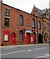
Former Christian Meeting House, Rodney Street, Wigan
The stone tablet on the wall at first floor level shows CHRISTIAN MEETING HOUSE 1858.
Banners in view in September 2017 show The Library and TO LET/MAY SELL.
Image: © Jaggery
Taken: 23 Sep 2017
0.00 miles
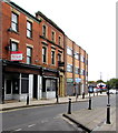
2
Krumbs Cafe, 6 Rodney Street, Wigan
Next door to TaskMaster on the corner of King Street.
Image: © Jaggery
Taken: 23 Sep 2017
0.01 miles
3
Franco's Italian Restaurant & Pizzeria, Wigan
At 5 Rodney Street.
Image: © Jaggery
Taken: 23 Sep 2017
0.02 miles
4
Royal Court Theatre building
On King Street.
Image: © philandju
Taken: 12 Nov 2013
0.02 miles
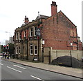
5
Former Baby Platinum club, King Street, Wigan
A To Let board is on the wall of the former gentlemen's club in September 2017.
Image: © Jaggery
Taken: 23 Sep 2017
0.02 miles
6
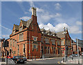
The History Shop - formerly Wigan Library
Image: © Dave Green
Taken: 31 Jul 2007
0.03 miles
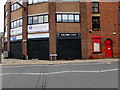
7
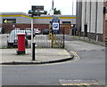
King Street signpost and pillarbox, Wigan
King Street car park is in the background.
Image: © Jaggery
Taken: 23 Sep 2017
0.03 miles
8
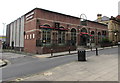
Revolution in Wigan
Signs at the entrance to Revolution at 49 King Street show COCKTAILS AND KITCHEN.
Image: © Jaggery
Taken: 23 Sep 2017
0.03 miles
9
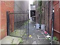
Gated alley between King Street and Library Street, Wigan
Image: © Gary Rogers
Taken: 31 Aug 2014
0.03 miles
10
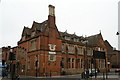
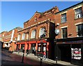
The 'Before' picture
"The History Shop" on the corner of Library Street and Rodney Street, just before restoration and refurbishment work began. Built in 1878 as Wigan's Free Public Library, designed by Alfred Waterhouse, who is most famous for the Natural History Museum in London. He also designed many prominent buildings in the region, including Liverpool University's Victoria building, of similar red brick to this - because of which the new generation of young Universities soon became tagged as 'red-brick universities'. Manchester Town Hall was another of Waterhouse's designs. Among his earliest public works are the set of Cemetery buildings less than a mile away on Warrington Road, Lower Ince. Sadly, the 1855/56 chapels there are being allowed to decay by the same Council which boasts of their care of this building.... All are Grade 2 Listed.
Image: © David Long
Taken: 18 Feb 2009
0.03 miles