IMAGES TAKEN NEAR TO
Grove Street, PONTEFRACT, WF9 3PL
Introduction
This page details the photographs taken nearby to Grove Street, WF9 3PL by members of the Geograph project.
The Geograph project started in 2005 with the aim of publishing, organising and preserving representative images for every square kilometre of Great Britain, Ireland and the Isle of Man.

There are currently over 7.5m images from over14,400 individuals and you can help contribute to the project by visiting https://www.geograph.org.uk
Image Map
Images are licensed for reuse under creativecommons.org/licenses/by-sa/2.0
Notes
- Clicking on the map will re-center to the selected point.
- The higher the marker number, the further away the image location is from the centre of the postcode.
Image Listing (7 Images Found)
Images are licensed for reuse under creativecommons.org/licenses/by-sa/2.0
Image
Details
Distance
2
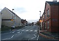
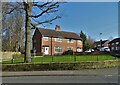
White Apron Street in South Kirkby
Otherwise known as the B6422 pictured at its junction with North Street.
Image: © Jonathan Clitheroe
Taken: 7 Nov 2016
0.13 miles
6
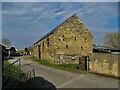
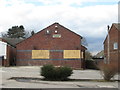
Old stone barn at Ball Park Farm, South Kirkby
Image: © Neil Theasby
Taken: 8 Mar 2022
0.20 miles
7
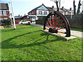
Remembering the coal miners, South Kirkby
Pit wheel memorial on the corner of Mill Lane and White Apron Street. South Kirkby Colliery was first sunk in 1881 and produced coal for the nation until 1988.
Image: © Neil Theasby
Taken: 8 Mar 2022
0.21 miles